Historic Preservation Scan-to-BIM: LOD 400 Ready

Robotic ImagingApril 9, 2026
Historic Preservation Scan-to-BIM Services
For architects and preservation consultants managing heritage documentation projects, the gap between what hand measurement can capture and what restoration fabrication requires creates real risk — to project schedules, regulatory compliance, and irreplaceable historic fabric. Robotic Imaging provides historic preservation scan-to-BIM services using LEICA RTC 360 survey-grade Laser Scanning (±1/16 inch accuracy, 2,000,000 points/second) to document ornate architectural details, structural irregularities, and deterioration conditions — delivering LOD 400 fabrication-ready BIM models for restoration craftspeople and regulatory compliance documentation meeting HABS/HAER and SHPO standards.
The Documentation Challenge in Historic Preservation Projects
Historic structures present a documentation problem that standard commercial methods cannot solve. Hand measurement across ornate plaster cornices, carved stone capitals, and compound-curved millwork profiles introduces cumulative error that exceeds restoration fabrication tolerances. Traditional total station surveys — even from skilled technicians — cannot achieve the ±1/16 inch accuracy a millwork shop or plaster restoration specialist needs to replicate a historic element exactly.
The consequences are tangible. Design drawings based on inaccurate existing conditions documentation lead to fabricated components that don't fit. Field adjustments to irreplaceable historic fabric cause damage that wasn't necessary. Change orders accumulate. And on projects where grant funding, historic tax credits, or SHPO approval depend on comprehensive pre-intervention documentation, incomplete records create compliance exposure that can jeopardize the entire project.
Historic preservation scan-to-BIM uses survey-grade Laser Scanning (LEICA RTC 360: ±1/16 inch accuracy, 2,000,000 points/second) to document ornate architectural details, structural irregularities, and deterioration conditions in heritage buildings. Deliverables include LOD 400 fabrication-ready Revit models for restoration craftspeople, point cloud archives, and regulatory documentation meeting HABS/HAER and SHPO standards — providing the verified existing conditions record that preservation projects require before any design decisions are made.
Ready to discuss your preservation documentation requirements? Request Historic Preservation Documentation to speak with our team.
Survey-Grade Accuracy: Why ±1/16 Inch Matters for Restoration

The LEICA RTC 360 captures 2,000,000 points per second at ±1/16 inch (±2mm) accuracy across a 130-meter range. For historic building documentation, those specifications translate directly into restoration capability.
Why point density matters for ornate detail: A carved Corinthian capital or a compound-curve plaster cornice cannot be hand-measured to a tolerance that a craftsperson can work from. The geometry is simply too complex — dozens of intersecting curves, varying depths, and undercut profiles that no tape measure or total station can fully characterize in three dimensions. At 2,000,000 points per second, the LEICA RTC 360 generates a dense three-dimensional record of every surface, including profiles impossible to capture through any other field method. That point cloud becomes the dimensional source of truth for fabrication.
Why ±1/16 inch matters for fabrication: Millwork shops operating from restoration profiles, plaster specialists replicating historic ceiling medallions, and masonry contractors repointing to match original joint profiles all work to tight tolerances. When the documentation is accurate to ±1/16 inch, the fabricated component fits. When documentation is derived from hand measurement with accumulated error, field adjustments become inevitable — and on historic fabric, every unnecessary intervention carries risk.
Photogrammetry comparison: Photogrammetry captures a visual record of historic surfaces and has legitimate uses in heritage documentation. What it does not provide is the three-dimensional measurement precision required for restoration fabrication profiles. Photogrammetry produces texture-rich surface images; Laser Scanning produces dimensionally precise point cloud geometry. For any work where a craftsperson needs to replicate a historic profile from documentation, ±1/16 inch survey-grade Laser Scanning is the required methodology.
What Historic Preservation Scan-to-BIM Documents
Historic building documentation projects vary significantly in scope — from single ornamental elements requiring LOD 400 fabrication profiles to full building existing conditions surveys for adaptive reuse. Our preservation scanning methodology covers the full range.
Ornate Architectural Details
Plaster cornices, column capitals, decorative friezes, carved stone ornamentation, historic millwork profiles, and cast iron facade elements all fall within what Robotic Imaging's LEICA RTC 360 capture methodology can fully document. The point cloud density at ±1/16 inch accuracy creates a complete three-dimensional record of complex ornamental geometry — sufficient to extract fabrication profiles, generate HABS measured drawings, and create LOD 400 Revit geometry for craftsperson coordination.
Structural Irregularities
Historic buildings rarely conform to their original construction drawings — if those drawings exist at all. Settlement, foundation movement, differential deflection, and decades of modifications mean that the actual structure frequently departs from any available record. Our Laser Scanning captures walls that are out-of-plumb, floors with differential settlement, and structural members with actual deflection profiles — not assumed straight-line dimensions. For preservation architects designing interventions, verified structural geometry eliminates the design assumptions that cause field conflicts and change orders.
Deterioration and Condition Mapping
The LEICA RTC 360's 360° HDR color imaging captures material conditions, surface finishes, and deterioration patterns simultaneously with geometric data. Spalling masonry, failed plaster sections, corroded metal elements, and water damage patterns are documented in spatial context — mapped to their precise location in the building model. This deterioration record serves both as a pre-intervention baseline for historic tax credit applications and as a planning tool for sequencing restoration work.
LOD 400 Fabrication-Ready Documentation for Restoration
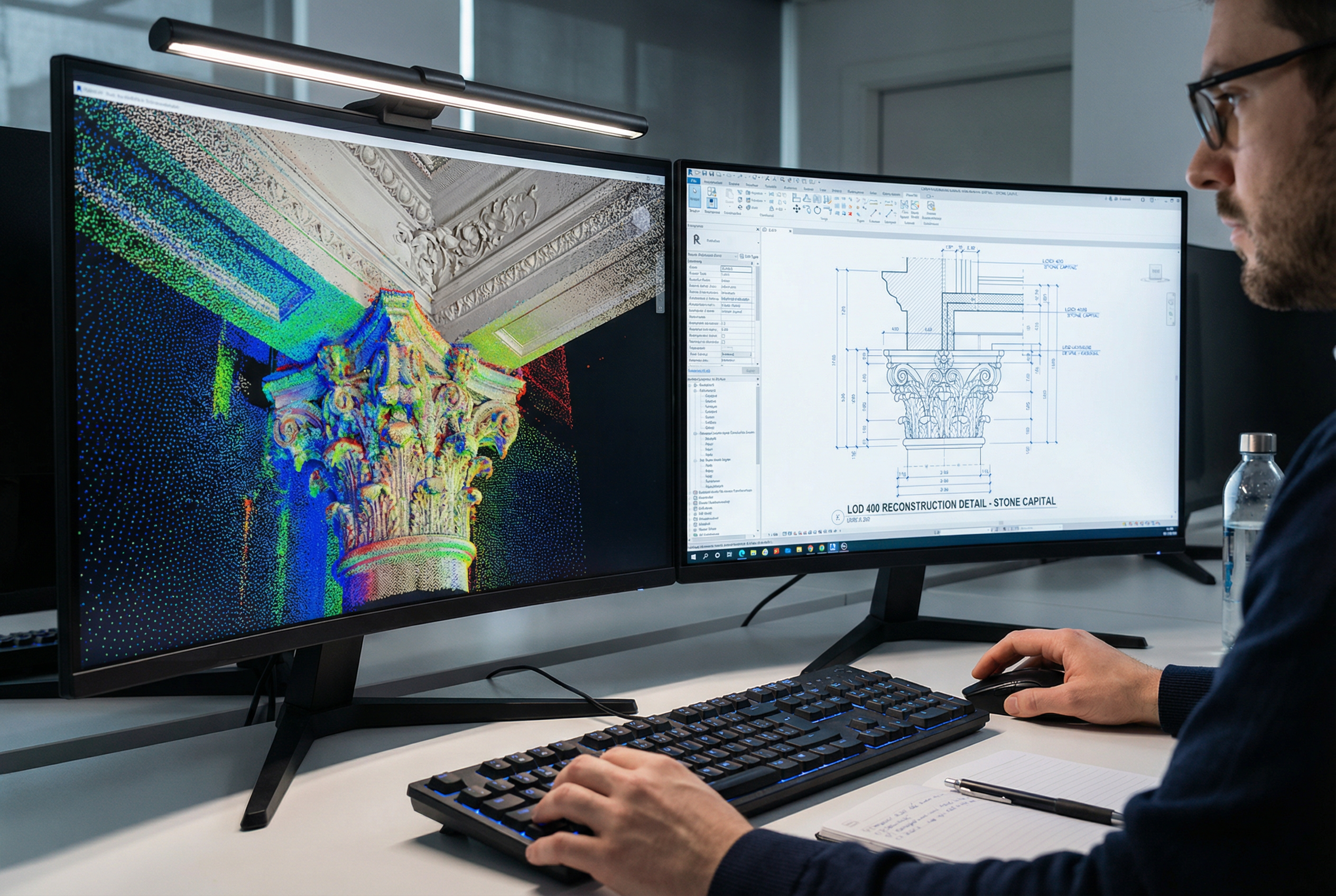
Level of Development 400 — LOD 400 — means fabrication-ready precision. It's the highest level of geometric and dimensional completeness specified in BIM delivery standards, and it's the deliverable that bridges the gap between scan data and the restoration craftsperson.
At LOD 400, a Revit model contains not just the location and approximate shape of an element but its precise dimensions, profiles, and connection geometry — the information a fabricator needs to produce that element without returning to the field for additional measurements. In restoration work, this distinction is critical:
- Millwork replication: A historic door surround or interior window casing requires exact profile documentation to produce shop drawings. LOD 400 Revit geometry extracted from ±1/16 inch scan data provides the dimensional accuracy millwork shops need to run correct profiles.
- Plaster restoration: Historic plaster ceiling elements — medallions, coffers, decorative moldings — require exact profile information for mold-making. Point cloud data at ±1/16 inch, processed into LOD 400 geometry, provides the three-dimensional record that replaces dozens of manual profile gauges and section cuts.
- Masonry repair and repointing: Joint profiles, coursing dimensions, and masonry unit sizes documented in LOD 400 provide the reference standard for selecting compatible replacement materials and directing field work.
- Structural stabilization elements: Steel lintels, historic iron tie rods, and timber framing members documented at LOD 400 give structural engineers actual cross-sections, not assumed standard profiles — essential for calculating actual load capacity of existing elements.
In a representative illustrative scenario — consider a historic courthouse with an ornate courtroom interior requiring plaster restoration — LOD 400 documentation would allow a plaster restoration specialist to fabricate replacement ceiling elements off-site with confidence that field installation will require no adjustment to historic adjacent surfaces. The cost of comprehensive scan documentation is recovered many times over in avoided field modification and change order costs.
Adaptive Reuse Applications
Adaptive reuse projects place scan-to-BIM documentation at the center of the design process. Converting a historic theater to a performing arts center, a historic industrial building to mixed-use residential, or a historic institutional building to contemporary office space requires integrating modern MEP systems, structural reinforcement, and code-compliant egress into an existing fabric that must be preserved with minimal intervention.
Without accurate existing conditions documentation, adaptive reuse design relies on assumptions that translate directly to conflicts during construction. MEP routing that appears viable in a design drawing fails when the actual ceiling plenum depth is two inches less than assumed. Structural reinforcement details that look straightforward in design conflict with embedded historic elements that weren't visible in incomplete survey drawings.
Robotic Imaging's adaptive reuse Laser Scanning captures full building geometry — including above-ceiling conditions, wall cavity configurations visible through access points, and existing MEP routing — in a single comprehensive survey. The resulting LOD 400 Revit model provides the existing conditions basis that adaptive reuse design teams need to:
- Route new MEP systems through actual available clearances, not assumed dimensions
- Design structural interventions that accommodate real wall thicknesses and embedded elements
- Minimize demolition scope by designing precisely around what exists
- Satisfy code compliance requirements with verified egress and accessibility documentation
- Support State Historic Preservation Office review with comprehensive pre-design documentation
For adaptive reuse projects specifically, the 2-3 day field capture → 10-14 business days total delivery timeline provides existing conditions documentation early enough to inform schematic design — not as a retrofit after design decisions have already been made. The project schedule value of that certainty is significant on grant-funded or tax credit-driven preservation projects where design milestones have funding implications.
Regulatory Compliance Documentation
Historic preservation projects operate within a specific regulatory framework that commercial scan-to-BIM providers typically have no experience with. HABS (Historic American Buildings Survey), HAER (Historic American Engineering Record), and SHPO (State Historic Preservation Office) documentation requirements are not generic measured drawing standards — they specify particular content, format, and accuracy requirements developed specifically for heritage buildings.
HABS/HAER compliance: The Historic American Buildings Survey and Historic American Engineering Record programs require large-format measured drawings at specific scales, photographic documentation to defined standards, and written historical and architectural data. Point cloud data from LEICA RTC 360 survey-grade scanning provides the measured drawing basis that HABS standards require — accurate to ±1/16 inch, with the three-dimensional geometry needed to generate accurate plan, section, and elevation drawings at any scale. The 360° HDR color imaging simultaneously satisfies HABS photographic documentation requirements.
SHPO documentation: State Historic Preservation Office review for Federal Historic Tax Credit projects, Section 106 consultations, and National Register nominations requires comprehensive existing conditions documentation as a baseline. Point cloud archives combined with LOD 400 BIM models and HDR photography provide a permanent pre-intervention record that satisfies SHPO evidentiary requirements and creates a long-term archive accessible through our cloud-based platform.
Secretary of the Interior's Standards: The Secretary of Interior's Standards for the Treatment of Historic Properties — the federal framework for rehabilitation, restoration, reconstruction, and preservation work — require that interventions be based on thorough documentation of existing conditions. Survey-grade scan documentation directly supports Standards compliance by demonstrating that design decisions were based on verified existing conditions, not assumptions.
Grant and tax credit applications: Federal and state historic preservation tax credit programs and grant applications frequently require comprehensive existing conditions documentation as part of the application package. LOD 400 BIM deliverables combined with point cloud archives and HDR photo documentation satisfies these requirements and creates the pre-intervention baseline that tax credit compliance reviews will reference.
For preservation consultants managing complex regulatory submissions, this combination of LOD 400 BIM models, point cloud archives, and 360° HDR documentation — all delivered in 10-14 business days — provides a single-source documentation package that addresses HABS, SHPO, and tax credit requirements simultaneously.
Getting Started with Historic Preservation Scan-to-BIM
Historic preservation projects are irreversible in a way commercial renovation projects are not. When a historic plaster cornice is removed incorrectly because documentation was inadequate, or when fabricated millwork doesn't fit because the source measurement had a half-inch error, the consequence isn't just a change order — it's damage to an asset that cannot be fully restored.
Survey-grade scan-to-BIM documentation eliminates the documentation-driven risk from preservation and restoration projects. Robotic Imaging's combination of LEICA RTC 360 ±1/16 inch accuracy, LOD 400 fabrication-ready Revit deliverables, and HABS/HAER/SHPO-compliant documentation packages — delivered in 10-14 business days from a field capture of 2-3 days — provides the verified existing conditions foundation that preservation architects and consultants need to design with confidence and deliver without field conflicts.
With 100+ million square feet documented across complex building types nationwide, our methodology is proven at scale across the full range of preservation project complexity — from single ornamental element documentation to full building adaptive reuse surveys.
Frequently Asked Questions:
What accuracy is required for historic preservation laser scanning? Restoration fabrication workflows require ±1/16 inch (±2mm) accuracy or better. The LEICA RTC 360 achieves ±1/16 inch, which is sufficient for millwork profile documentation, plaster replication mold-making, and masonry repair specifications.
What LOD level is needed for restoration fabrication documentation? LOD 400 (Level of Development 400) is the appropriate deliverable for restoration craftsperson coordination — it provides fabrication-ready dimensional precision that LOD 300 or LOD 350 documentation cannot support for complex ornamental elements.
Can laser scanning produce HABS/HAER compliant measured drawings? Yes. Point cloud data from survey-grade Laser Scanning provides the measured drawing basis that HABS standards require, with 360° HDR photography satisfying photographic documentation requirements simultaneously.
How does scan-to-BIM support adaptive reuse of historic buildings? Scan-to-BIM provides verified existing conditions geometry — including above-ceiling and wall cavity conditions — that enables adaptive reuse design teams to route MEP systems and design structural interventions based on actual dimensions, minimizing conflicts with historic fabric and reducing construction-phase change orders.
Facing documentation gaps on a preservation or adaptive reuse project?
- Request Historic Preservation Documentation — Describe your project scope and receive a customized documentation proposal
- Schedule a Preservation Consultation — Speak directly with our team about HABS/HAER, SHPO requirements, and LOD 400 deliverables for your specific building
- Request Preservation Quote — Get scope-specific pricing for your historic documentation project
Contact Robotic Imaging today to ensure your preservation project begins with the verified existing conditions documentation it requires.