LiDAR Technology in Construction: What AEC Professionals Need to Know
Robotic ImagingJune 3, 2026
LiDAR Technology in Construction: What AEC Professionals Need to Know
LiDAR technology in construction captures precise three-dimensional data of any building or site using pulsed laser light. It measures return times from millions of laser pulses per second to build a dense Point Cloud — a digital record of every measurable surface. For AEC professionals, that Point Cloud is the foundation for Scan-to-BIM documentation and accurate as-built drawings.
LiDAR stands for Light Detection and Ranging. First developed for aerospace and geospatial surveying, it has become a standard tool in commercial construction over the past decade. Robotic Imaging deploys this technology across the United States, documenting over 100 million square feet of commercial space since 2017 — from single-building renovations to multi-site portfolio programs for Fortune 500 clients.
What Is LiDAR Technology? The Core Principles Explained
A LiDAR scanner emits rapid laser pulses in a sweeping rotational pattern and records how long each pulse takes to return after reflecting off a surface. Because laser light travels at a fixed speed, that return time translates directly into a precise distance measurement. Repeating this process millions of times per second produces a Point Cloud — millions of individually measured three-dimensional points, each with precise X, Y, and Z coordinates.
Viewed together, those points describe the complete geometry of the scanned environment: walls, floors, columns, ceilings, ductwork, pipes, and structural elements. For a complete building survey, technicians place the scanner at multiple positions and align all individual scans into one unified dataset. Unlike photographs, a Point Cloud is a spatial measurement dataset — it can be dimensioned, sectioned, and exported long after the field visit ends, making it a permanent record of existing conditions.
Three Types of LiDAR Technology Used in AEC Construction
Three equipment categories cover the majority of commercial AEC applications, each suited to different project scales and site conditions.
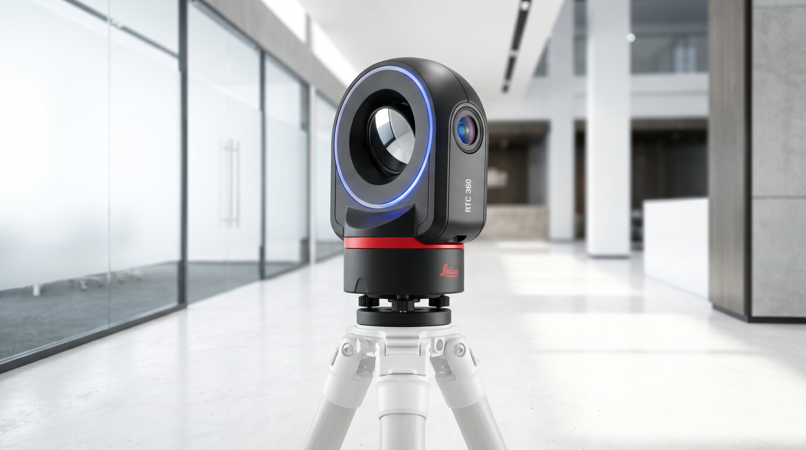
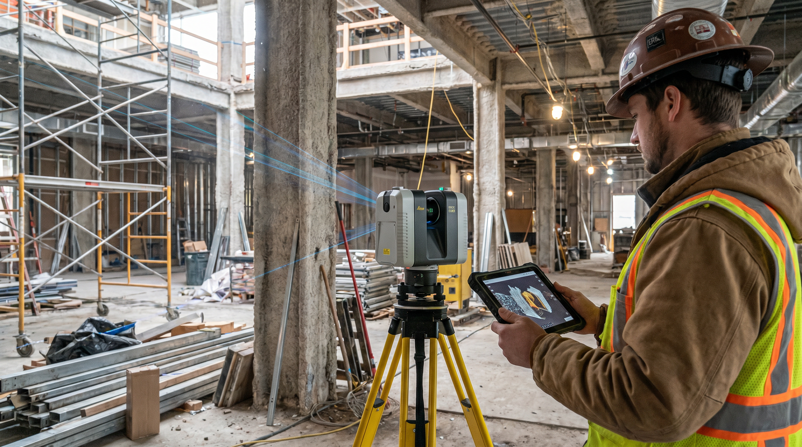
Terrestrial scanners are stationary, tripod-mounted instruments for interior and exterior building documentation. They deliver the highest accuracy and point density for close-range work. Robotic Imaging operates LEICA RTC 360 scanners that capture 2,000,000 points per second at ±2mm accuracy across ranges up to 130 meters — the field standard for Scan-to-BIM production on commercial renovation and construction projects.
Mobile and handheld systems are carried by an operator moving through a space. They trade some accuracy for speed and maneuverability, making them effective in warehouses, transit corridors, and occupied environments where tripod deployment is impractical.
Drone-mounted systems (UAV-based) attach scanning sensors to unmanned aerial vehicles for aerial surveys. Robotic Imaging's FAA Part 107 certified pilots deploy these for roof documentation and large-site surveys as part of the firm's Laser Scanning services. Many commercial engagements combine terrestrial and drone-based scanning within a single project scope.
How LiDAR Technology Is Applied in Architecture, Engineering, and Construction
In commercial construction, this scanning approach primarily captures existing building conditions before new design work begins. Without that accurate existing-conditions record, architects and engineers work from outdated drawings or manual field notes that cannot capture the full three-dimensional complexity of an occupied building.
Common applications include:
- As-built documentation for commercial renovations and tenant improvement projects
- MEP system capture for coordination and clash detection in existing buildings
- Structural assessments for industrial facilities and historic structures
- Site surveys and topographic mapping ahead of ground-up construction
- Pre-construction coordination using Point Cloud data in Navisworks or similar platforms
- Facility condition assessments for maintenance planning and capital budgeting
Robotic Imaging has applied this technology in construction engagements for clients including Walmart, Kroger, CVS, and 7-Eleven across 1,000+ sites. Point Cloud output is delivered in RCS, RCP, E57, or LAS format for direct import into Revit, AutoCAD, or Navisworks.
What LiDAR Technology Advances Are Reshaping AEC Practice?
Several hardware and software developments have materially changed how these systems are deployed on commercial projects over the past several years.
Higher Capture Speed with Greater Accuracy
Robotic Imaging completes most commercial building surveys in 2–3 days of field capture — 50–80% faster than traditional surveying — using LEICA RTC 360 scanners at 2,000,000 points per second and ±2mm accuracy across 130-meter ranges.
Smaller, More Portable Equipment
Compact, single-operator instruments now access narrow mechanical rooms, elevated structural zones, and confined utility areas that earlier tripod-based units could not reach — without sacrificing the data quality required for Scan-to-CAD and BIM production.
UAV Integration for Aerial Documentation
Drone-mounted sensors deliver orthomosaic deliverables at 1–3 cm per pixel resolution for roof and site documentation, making aerial surveys viable for commercial projects where rooftop access is limited or where large land areas require comprehensive coverage.
Automated Processing and AI-Assisted Modeling
Registration algorithms now align multiple scan positions in hours rather than days. AI feature extraction tools automatically identify walls, floors, columns, and MEP elements from raw Point Cloud data, reducing manual modeling time on complex commercial projects.
How Does LiDAR Technology Connect to BIM Workflows?
The connection between LiDAR technology and Building Information Modeling defines the Scan-to-BIM process. The workflow follows a consistent sequence from field capture to final deliverable:
Field Capture (2–3 Days)
Scanners document the building from multiple positions, producing raw Point Cloud files for each location. Robotic Imaging dispatches field crews within 2–3 days of project authorization.
Point Cloud Processing (3–5 Days)
Individual files are registered and merged into a unified three-dimensional dataset, output in the client's required format: RCS, RCP, E57, or LAS.
BIM Modeling (7–10 Days)
Technicians trace the registered Point Cloud in Revit to produce models at the required Level of Development — LOD 200, LOD 300, LOD 350, or LOD 400 — with tolerances from ±1/4 inch at LOD 300 to ±1/16 inch at LOD 400.
Deliverable Output (10–14 Days Total)
Finished BIM models are delivered within 10–14 business days. Representative deliverables are available in the 3D model gallery.
Working from a LiDAR-derived BIM model directly reduces design conflicts, change orders, and field discoveries that occur when teams rely on estimated or outdated documentation.
Document Your Building with LiDAR Precision
Robotic Imaging delivers Scan-to-BIM documentation from $0.19/sqft with a 10–14 business day turnaround. LEICA RTC 360 scanners at ±2mm accuracy. ISO 27001 certified and SOC 2 Type II compliant.
Get a Free QuoteFrequently Asked Questions About LiDAR Technology in Construction
What is LiDAR technology used for in construction?
LiDAR technology in construction is used to capture precise three-dimensional Point Cloud data of existing buildings and sites. It enables as-built documentation, MEP coordination, structural assessments, and site surveys that feed directly into Scan-to-BIM and Scan-to-CAD workflows. The resulting digital records reduce design errors and change orders on renovation and retrofit projects.
How accurate is LiDAR scanning for building documentation?
Accuracy depends on equipment type. The LEICA RTC 360 achieves ±2mm — significantly tighter than the ±3–4mm range typical of most competing scanners. That accuracy supports LOD 300 BIM deliverables at ±1/4 inch tolerance and LOD 350 at ±1/16–1/8 inch from the Point Cloud.
How does LiDAR scanning compare to traditional surveying?
Traditional surveying captures sparse individual measurements using total stations and tape measures. Laser Scanning captures millions of measurements per second across a full 360-degree field of view, producing complete spatial geometry — 50–80% faster than manual methods for commercial building documentation projects.
How does LiDAR Point Cloud data connect to Revit and AutoCAD?
Point Cloud files in RCS, RCP, E57, or LAS format import directly into Autodesk Revit, AutoCAD, and Navisworks. The Point Cloud serves as the geometric reference for BIM modeling — technicians trace it to produce LOD-compliant BIM objects for walls, floors, MEP systems, and structural elements at the specified Level of Development.
All pricing, delivery timelines, accuracy specifications, and client references reflect verified data from roboticimaging.com as of June 2026. Robotic Imaging is ISO 27001 certified and SOC 2 Type II compliant.