Scan-to-BIM Services | Complete 3D Documentation | Robotic Imaging
Robotic ImagingFebruary 26, 2026
Complete Guide to Scan-to-BIM Services for Commercial Buildings
Scan-to-BIM services use Laser Scanning to capture commercial buildings as precise Point Clouds — millions of 3D measurements collected during a 2-3 day field capture phase — then convert that data into accurate Revit BIM models at Level of Development (LOD) 200 through LOD 400. Robotic Imaging delivers as-built documentation for commercial buildings within 10-14 business days, combining LEICA RTC 360 field capture at ±1/16 inch accuracy with LOD-specific BIM modeling workflows trusted by architects, facilities managers, and construction teams nationwide.
Traditional surveying methods take 3-6 weeks, deliver 2D drawings with ±3-6 inch tolerances, and provide no path to BIM coordination. Scan-to-BIM services eliminate that bottleneck — replacing manual measurement with millimeter-grade reality capture that feeds directly into Revit workflows, clash detection, and renovation planning without field verification callbacks.
Robotic Imaging has documented more than 100 million square feet across Fortune 500 portfolios including 7-Eleven (2,400+ stores), Kroger (1,800+ locations), Ross, Burlington, AutoZone, Speedway, Nordstrom, Guitar Center, JLL, and Colliers Engineering. This guide covers the complete scan-to-BIM process, LOD selection framework, equipment capabilities, deliverable formats, and how to evaluate providers for commercial building documentation projects.
How Scan-to-BIM Works: The Complete 4-Phase Process
Understanding the scan-to-BIM workflow helps project teams set accurate expectations for timelines, deliverable quality, and coordination requirements. Robotic Imaging executes a four-phase process that moves from field capture to final BIM deliverables within 10-14 business days — 50-80% faster than traditional surveying methods.
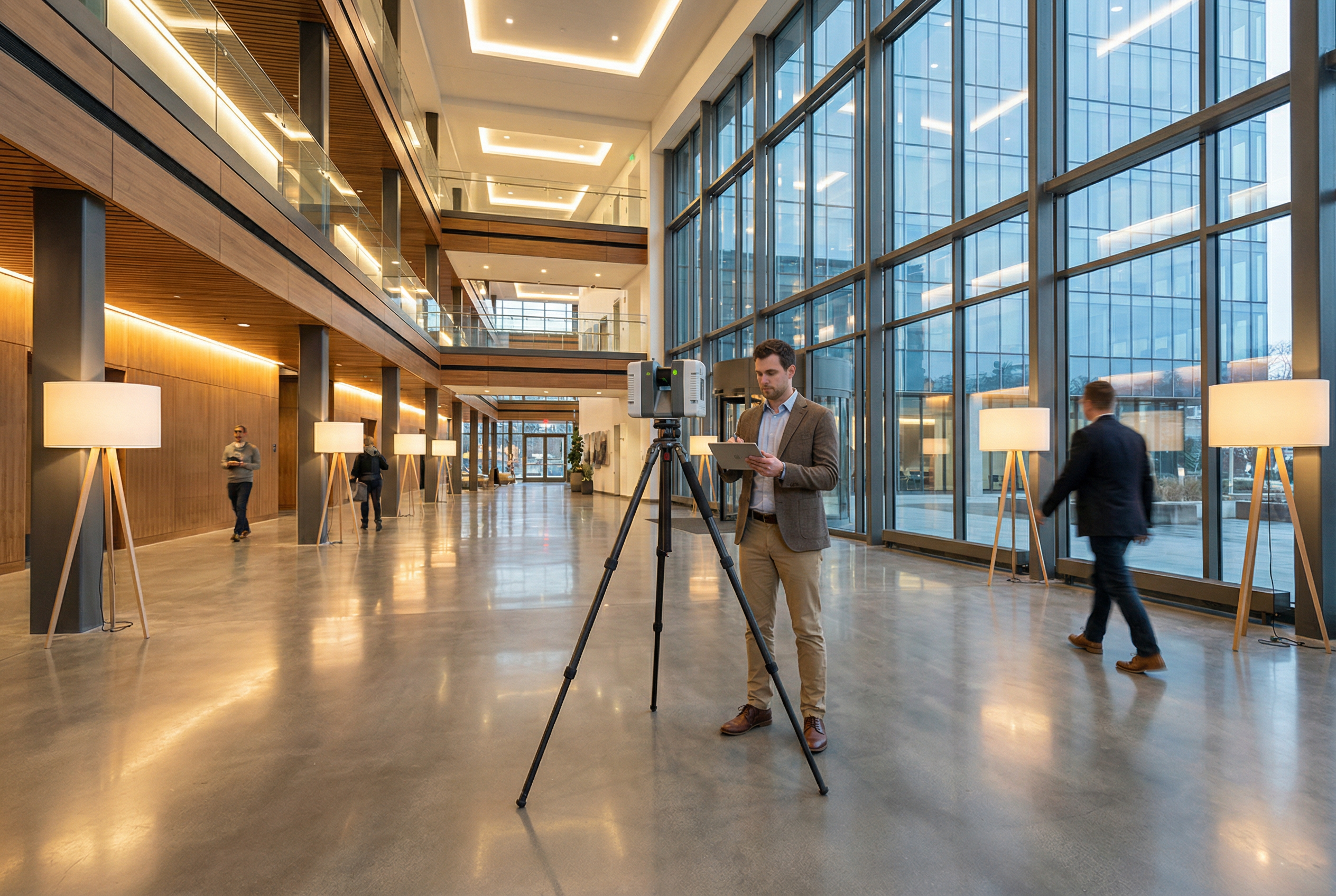
Phase 1 — Field Capture (2-3 Days)
Field technicians deploy high-accuracy 3D laser scanners throughout the building, capturing overlapping scan positions that cover every surface, system, and spatial condition. The LEICA RTC 360 captures 2,000,000 points per second at ±1/16 inch accuracy, completing large commercial floors in minutes per scan position. Occupied buildings are accommodated through 24/7 scheduling — overnight and weekend capture windows eliminate disruption to business operations. This phase produces raw scan data: millions of georeferenced 3D measurements that form the foundation for all downstream deliverables.
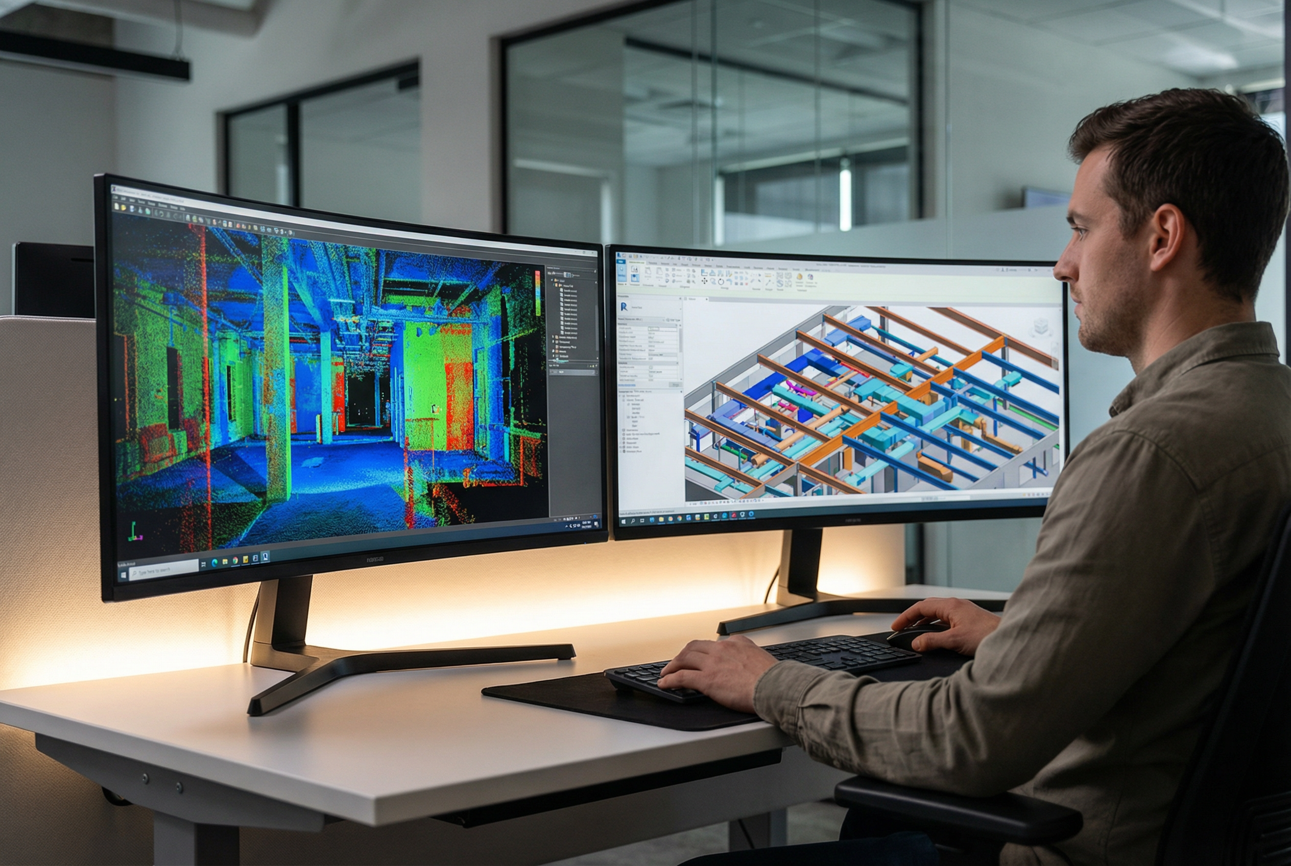
Phase 2 — Point Cloud Processing (3-5 Days)
Raw scan data undergoes registration — the process of aligning individual scan positions into a unified, georeferenced Point Cloud. Processing workflows apply quality control checks, filter noise, and validate dimensional accuracy against field control points. Processed point clouds are delivered in multiple formats (RCS, E57, LAS) for teams who need raw reality capture data independent of BIM modeling. This phase is where data integrity is established; accuracy gaps caught here are significantly less expensive to resolve than errors discovered during construction.
Phase 3 — BIM Modeling (7-10 Days)
BIM modelers work from the validated Point Cloud to construct LOD-specific Revit models. Every wall, structural element, MEP system, and architectural feature is modeled to the precision level specified for the project phase — LOD 200 for schematic design, LOD 300-350 for design development and construction documents, LOD 400 for fabrication-level documentation. Modeling teams follow client-specific Revit standards and template requirements, not generic defaults.
Phase 4 — Quality Control and Delivery
Completed models undergo multi-stage QC: dimensional validation against point cloud measurements, LOD compliance review, and deliverable format confirmation. Final packages include Revit .rvt files, point clouds, 2D CAD .dwg drawings, and 360° VR tour assets as specified. Total elapsed time from field mobilization to final deliverable: 10-14 business days.
LOD Level Selection Framework for Commercial Buildings
Choosing the correct Level of Development determines project cost, modeling timeline, and whether the deliverable will actually support your workflow without rework. The following framework gives architects, BIM managers, and project owners a practical decision tool for commercial building documentation.
LOD 200 — Schematic Design and Feasibility
LOD 200 models represent building elements as approximate geometry — walls, floors, columns, and major MEP systems shown at conceptual scale without precise dimensions or detailed connections. Appropriate for feasibility studies, space planning, and early programming phases where design intent matters more than dimensional precision. Typically captured using LEICA BLK 360 or MATTERPORT Pro3 equipment. Accuracy: ±1/4 inch to ±3/4 inch depending on scanner selection.
LOD 300 — Design Development and Construction Documents
LOD 300 models contain specific geometry, accurate dimensions, and defined quantities for all building elements. This is the standard specification for design development, construction documentation, permit submissions, and coordination meetings. Architectural elements, structural systems, and primary MEP runs are modeled with sufficient precision for contractor coordination and code review. LEICA RTC 360 at ±1/16 inch accuracy is the recommended capture platform for LOD 300 projects requiring field verification-free deliverables.
LOD 350 — Construction Coordination
LOD 350 adds interface and connection information to LOD 300 geometry — how systems connect, how trades coordinate at intersections, and how elements interface with adjacent assemblies. This level supports clash detection workflows, enabling MEP coordination before construction begins. LOD 350 is increasingly the standard for renovation projects, tenant improvements, and any scope involving significant MEP coordination. For MEP engineers specifically, LOD 350 captures provide the dimensional data needed to design around existing conditions without site revisits.
LOD 400 — Fabrication and Installation
LOD 400 models contain full fabrication-level geometry — complete dimensions, materials, finishes, and installation details for every modeled element. Used for prefabricated component design, specialty system installation, and construction verification. LOD 400 engagements require the highest accuracy capture (LEICA RTC 360 or ScanStation P40/P50 at survey-grade accuracy) and extended modeling timelines.
LOD Selection Quick Reference:
| Project Phase | Recommended LOD | Typical Use Case | Scanner Recommendation |
|---|---|---|---|
| Feasibility / Programming | LOD 200 | Space planning, concept design | LEICA BLK 360, MATTERPORT Pro3 |
| Design Development | LOD 300 | CD sets, permit submissions | LEICA RTC 360 |
| Construction Coordination | LOD 350 | Clash detection, MEP coordination | LEICA RTC 360 |
| Fabrication | LOD 400 | Prefab components, installation | LEICA RTC 360, ScanStation P40/P50 |
When project requirements span multiple phases, Robotic Imaging recommends capturing at the highest LOD required — point cloud data collected at LOD 350-400 accuracy can be used to deliver LOD 200 models while retaining the raw data for future phases.
Industry Applications for Commercial Building Documentation
Scan-to-BIM services address documentation challenges across commercial building types that share a common problem: existing conditions data that is outdated, inaccurate, or simply unavailable when design and construction teams need it most.
Retail and Multi-Location Programs
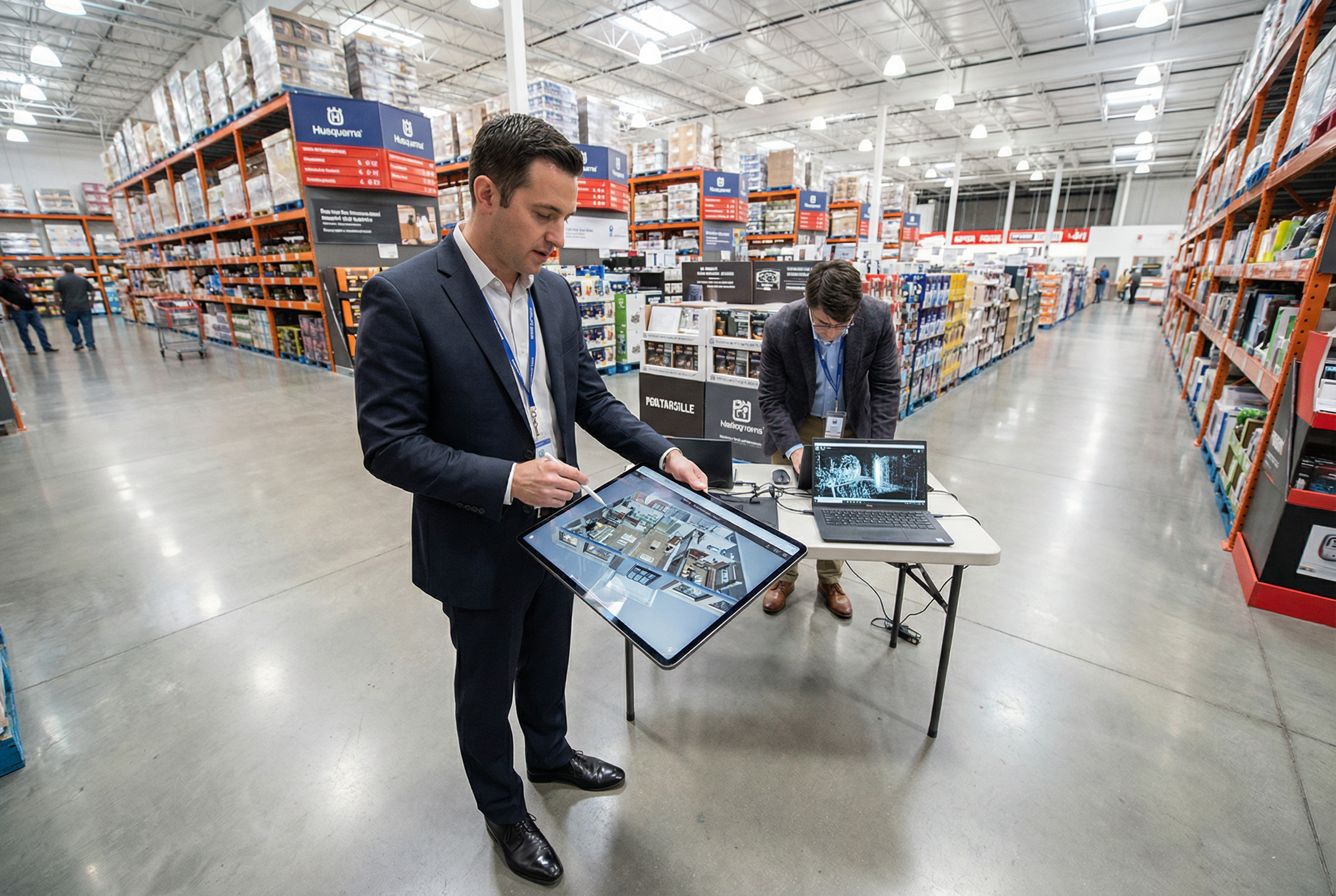
Retail facilities management teams running store renovation, remodel, or refresh programs face a coordination challenge traditional surveying cannot solve at scale: getting accurate, consistent as-built data across hundreds of locations on accelerated timelines without disrupting store operations. Robotic Imaging executes overnight and off-hours scanning windows that leave retail operations undisturbed while delivering LOD 300 Revit models within two weeks. The 7-Eleven 2,400+ store documentation program and Kroger 1,800+ location program represent the scale of enterprise retail documentation Robotic Imaging delivers — consistent data quality across geographically distributed portfolios managed through a centralized proprietary platform.
Commercial Office and Tenant Improvement
Office building repositioning, tenant improvement buildouts, and base building documentation projects require accurate as-built conditions before design can begin. Floor plate dimensions, ceiling heights, structural grid, and MEP rough-in locations all affect TI design scope and cost. LEICA RTC 360 capture at ±1/16 inch accuracy provides the dimensional reliability architects need to deliver construction documents without field verification callbacks — a direct reduction in project cost and schedule.
Industrial Facility Scanning
Industrial facilities — distribution centers, manufacturing plants, and processing facilities — present extended-range scanning requirements that demand equipment with longer range and higher point density. The LEICA ScanStation P40 and P50 deliver survey-grade accuracy across large open volumes, capturing equipment, structural steel, and process piping in environments where traditional measurement is impractical. Industrial scan-to-BIM applications include equipment layout documentation, facility expansion planning, and digital twin creation for ongoing operations management.
Historic Preservation
Historic buildings present unique documentation challenges: complex geometry, varied materials, irregular forms, and the need for non-contact measurement that doesn't disturb fragile surfaces. Laser scanning captures historic structures with millimeter-grade accuracy without physical contact, producing the complete geometric record preservation architects need for rehabilitation design, code compliance submissions, and grant documentation.
Equipment Capabilities and Accuracy Standards
Equipment selection determines accuracy, capture speed, and appropriate application range for scan-to-BIM projects. Robotic Imaging operates a seven-scanner arsenal matched to project requirements — the right tool for each building type, LOD specification, and site condition. This is the equipment specification table competitors decline to publish:
| Equipment | Capture Rate | Range | Accuracy | Best For |
|---|---|---|---|---|
| LEICA RTC 360 | 2,000,000 pts/sec | 130m | ±1/16 inch | Large commercial, LOD 350-400 |
| LEICA BLK 360 | 680,000 pts/sec | 60m | ±1/4 inch | Standard projects, LOD 200-300 |
| LEICA BLK 2GO | — | — | — | Mobile scanning, large corridors |
| MATTERPORT Pro3 | 100,000 pts/sec | 20m standard | ±3/4 inch at 10m | VR tours, LOD 200 walkthroughs |
| MATTERPORT Pro2 | — | — | — | 360° visual documentation |
| Leica ScanStation P40 | High-density | Long range | Survey-grade | Industrial, large-volume facilities |
| Leica ScanStation P50 | High-density | Long range | Survey-grade | Outdoor, campus-scale documentation |
No provider using a single scanner type can consistently match the accuracy requirements of every project phase. A MATTERPORT Pro3 at ±3/4 inch is appropriate for marketing-grade virtual tours but insufficient for LOD 300 construction documentation. The LEICA RTC 360 at ±1/16 inch exceeds manual measurement accuracy for LOD 350-400 deliverables. Matching equipment to LOD requirement is the fundamental quality control decision in scan-to-BIM services.
For project teams asking "will the model be accurate enough to eliminate field verification trips?" — the answer depends entirely on which equipment captured the data and whether LOD specification matched project requirements. Robotic Imaging's equipment selection process begins with LOD deliverable requirements, not equipment availability.
Scan-to-BIM Deliverables and Output Formats
Deliverable format compatibility with existing design and construction workflows determines how quickly project teams can act on scan-to-BIM data. Robotic Imaging provides comprehensive deliverable packages covering every format commercial building projects require:
BIM Model Deliverables:
- Revit .rvt files — Native Revit models at specified LOD (200-400), built to client template standards and Revit version requirements
- LOD-compliant geometry — Walls, floors, ceilings, structural systems, MEP runs, and architectural elements modeled to specification
Point Cloud Deliverables:
- RCS / RCP — Autodesk-native formats for direct Revit point cloud linking and AutoCAD integration
- E57 — Universal exchange format compatible with all major BIM and CAD platforms
- LAS / LAZ — GIS-compatible formats for site and civil integration
2D Documentation:
- AutoCAD .dwg — Floor plans, reflected ceiling plans, sections, and elevations derived from point cloud geometry; suitable for permit submissions and contractor coordination
Visual Documentation:
- 360° VR Tours — Interactive virtual walkthroughs for remote site review, client presentations, and facility management reference
Deliverable packages are configured to project specifications during scope definition — not a standard bundle applied uniformly. Enterprise multi-location programs receive consistent deliverable structures across all sites, enabling direct comparison and portfolio-level analysis through Robotic Imaging's proprietary web and mobile platform.
Why Choose Robotic Imaging for Scan-to-BIM Services
Commercial building teams evaluating scan-to-BIM service providers are weighing five criteria that separate capable providers from vendors: accuracy guarantees, timeline certainty, enterprise scalability, platform access, and verifiable client track record. Robotic Imaging addresses each directly.
Verified Accuracy at Scale
LEICA RTC 360 capture at ±1/16 inch accuracy — more precise than manual measurement — backed by 100+ million square feet of documented commercial buildings. This is not a marketing accuracy claim; it is a published equipment specification tied to real deliverables at enterprise scale.
Timeline Certainty
10-14 business days from field mobilization to final deliverable. The phase breakdown is specific: 2-3 days field capture, 3-5 days point cloud processing, 7-10 days BIM modeling. Not "as fast as possible." A defined, repeatable process.
Enterprise Multi-Location Scalability
Fortune 500 retail programs at 2,400+ and 1,800+ location counts require more than scanning capability — they require project management systems, consistent quality protocols, and nationwide field coverage that scales without degrading. Robotic Imaging's 24/7 scheduling capability and nationwide coverage enable off-hours capture across distributed portfolios at program scale.
Proprietary Platform Access
Unlike providers who deliver files and disengage, Robotic Imaging provides ongoing access to project data through a proprietary web and mobile dashboard (iOS and Android). Project visibility during modeling, centralized data access post-delivery, and customizable reporting — capabilities that matter for facilities teams managing multi-location portfolios rather than individual project deliverables.
Proven Fortune 500 Client Track Record
7-Eleven, Kroger, Ross, Burlington, AutoZone, Speedway, Nordstrom, Guitar Center, JLL, Colliers Engineering, and Nelson Worldwide have trusted Robotic Imaging for commercial building documentation at scale. Enterprise clients with 100+ location programs don't return without consistent quality and reliable delivery.
> Ready to discuss your commercial building documentation program? Contact Robotic Imaging to request an enterprise quote tailored to your portfolio scale, LOD requirements, and timeline.
Conclusion and Next Steps
Scan-to-BIM services have redefined what commercial building documentation can deliver — replacing 3-6 week traditional surveying timelines and ±3-6 inch manual tolerances with millimeter-grade Point Cloud capture and LOD 300-400 Revit models delivered in 10-14 business days. For architects eliminating field verification trips, facilities managers coordinating multi-location remodel programs, and BIM managers integrating as-built data into design workflows, the capability gap between 3D laser scanning and traditional methods has become too significant to ignore.
The decision criteria that matter for commercial building scan-to-BIM engagements are straightforward: accuracy tolerance aligned to LOD requirement, timeline commitment backed by a defined process, deliverable formats that integrate with existing workflows, and a provider track record that demonstrates enterprise-scale execution — not individual project anecdotes.
Robotic Imaging has documented more than 100 million square feet across Fortune 500 commercial and retail portfolios. The seven-scanner equipment arsenal, proprietary project platform, 24/7 scheduling capability, and 10-14 business day delivery timeline represent a documented service standard, not a marketing position.
Three ways to move forward:
- Request a Project Quote — Provide your building size, LOD requirement, and timeline. Receive a scoped proposal within one business day.
- Schedule a Consultation — Discuss multi-location program requirements, portfolio documentation strategy, or LOD selection with a Robotic Imaging project specialist.
- Download the LOD Selection Guide — A practical decision framework matching project phase, accuracy tolerance, use case, and equipment recommendation — designed for architects and BIM managers evaluating deliverable specifications.
Contact Robotic Imaging today to discuss your commercial building documentation requirements.