BIM Terminology Explained
Robotic ImagingJanuary 14, 2022
We understand that in the world of scanning, there might be new terminology you are not aware of. So, this article breaks down important terminology. With all the acronyms and specialized terminology, things can get confusing! This post will walk you through the basics and clarify terminology differences.
BIM
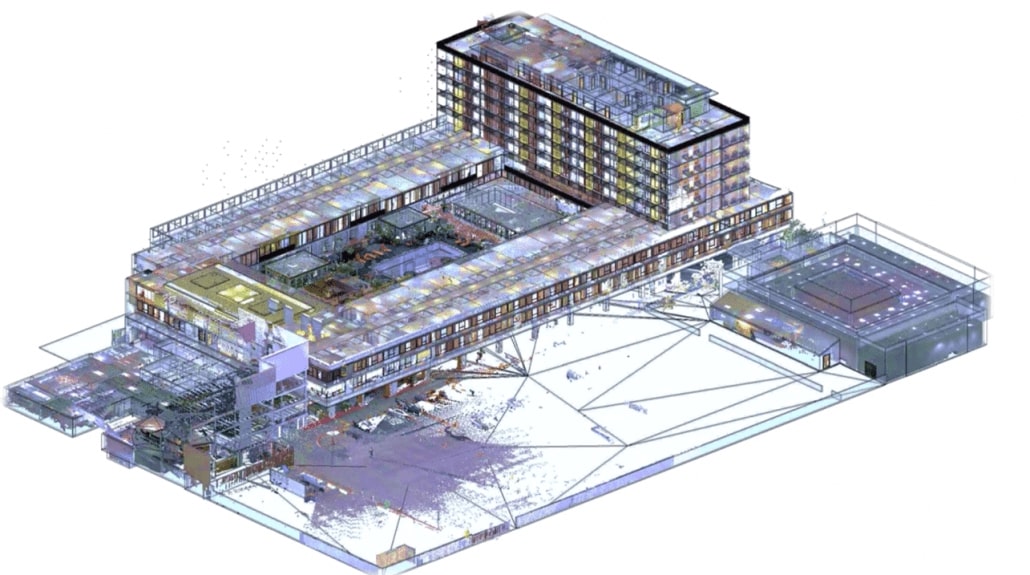
BIM stands for “Building Information Modeling,” which is the methodology of creating a building information model. Softwares such as AutoDesk Revit are used to craft a building information model, but the actual act itself is commonly referred to as BIM.
A BIM includes critical information about the physical building but also functional information. Geometric models and elements, such as doors, windows, beams are hosted inside larger digitized building components. These elements can show the materials used, location, and dimensions. BIM can also show the building’s history and how it evolved over time.
Scan-to-BIM
This is a process of using laser scanners that capture highly accurate dimensional information of an existing building. This data collected is then later used to create a BIM.
Scan-to-BIM has been a popular method used in architecture, engineering, and construction. Because laser measurements are highly precise, it enables the BIM to be more accurate and up to date vs. referencing previous building and construction documents. Many buildings’ physical state differs from the original building plans and documentation.
Suggested reading: If you want to learn more about the purpose of BIM, check out this article.
LOD
LOD stands for level of development. There are certain levels of detail achieved in digital models. For example, LOD 100 is the lowest level. It means that a BIM might include a generic representation of a light fixture, information about its cost, and general indication of placement. LOD 400 is the highest level. In a LOD 400 model, components are modeled with high enough detail, that you can fabricate a replacement. A light fixture, for example, might even include details about its mounting.
The LOD for any scan-to-BIM project is typically determined by its stakeholders and project managers. So, this aspect varies by project.
3D CAD Model
A 3D CAD model is a spatial model produced by a CAD software program. A primary CAD software still used often today is AutoCAD. 3D CAD typically uses “dumb” lines to represent building elements. Lines are not grouped together into objects, and do not show a database of information about the building.
LiDAR Scanner
LiDAR stands for light detection and ranging. Essentially, a LiDAR scanner uses light to determine the distance between two objects. Laser scanning is highly accurate as it makes the built environment using laser beams to capture measurements and even color! These points are then scrupulously plotted and stitched to produce a 3D representation of the building project. These plotted points that represent a specific space are known as point clouds.
Point Clouds
Point clouds are plotted data points that represent space. A single point is plotted in an X, Y, Z coordinate and will represent an underlying sampled surface. Multiple data points will collate into multiple spatial measurements and therefore can effectively represent entire interior or exterior spaces. Sometimes, additional data, like color and luminance value, can be stored in an RGB format.
Each point from a LiDAR scan represents a single scanned measurement, which is highly accurate then stitched together to accurately capture the built environment. This process is called “registration.” Point clouds are typically converted and then translated into BIM models, which are valuable to architects, developers, and construction managers.