Property Manager Scan-to-BIM: TI & Repositioning

Robotic ImagingApril 9, 2026
Property Manager Scan-to-BIM for Tenant Improvements and Building Repositioning
For property managers overseeing commercial office buildings, outdated or missing as-built documentation creates cascading problems: tenant improvement projects stall while architects wait for field verification, TI allowance disputes arise when field conditions differ from lease assumptions, and building repositioning initiatives lack accurate scope to justify capital investment. Robotic Imaging delivers property manager scan-to-BIM services combining LOD 300 existing conditions documentation with MATTERPORT Pro3 360° virtual tours — supporting TI coordination, repositioning planning, and lease velocity acceleration from a single site mobilization, delivered in 10-14 business days.
Property manager scan-to-BIM provides LOD 300 core and shell documentation — including floor plates, column grids, ceiling heights, and MEP systems — supporting tenant improvement coordination, building repositioning scope definition, and lease velocity acceleration through integrated 360° virtual tours. Delivered in 10-14 business days, existing conditions models give tenant architects verified baselines while Matterport virtual tours accelerate leasing decisions.
Property Management Documentation Challenges
Commercial office properties carry a documentation problem that compounds over time. Original construction drawings age out of accuracy as tenants come and go, building systems get modified, and informal renovations accumulate without record. By the time a major tenant improvement project or repositioning initiative arrives, property managers are left managing expensive construction scopes against drawings that may be decades out of date.
The consequences are predictable and costly. A tenant's architect spends the first weeks of a TI engagement conducting field verification trips — measuring, photographing, reconciling discrepancies — before design work can begin. When field conditions exceed TI allowance assumptions, disputes follow. Repositioning feasibility studies built on inaccurate square footage or ceiling height assumptions lead to capital planning errors that surface late in the project cycle, when corrections are most expensive.
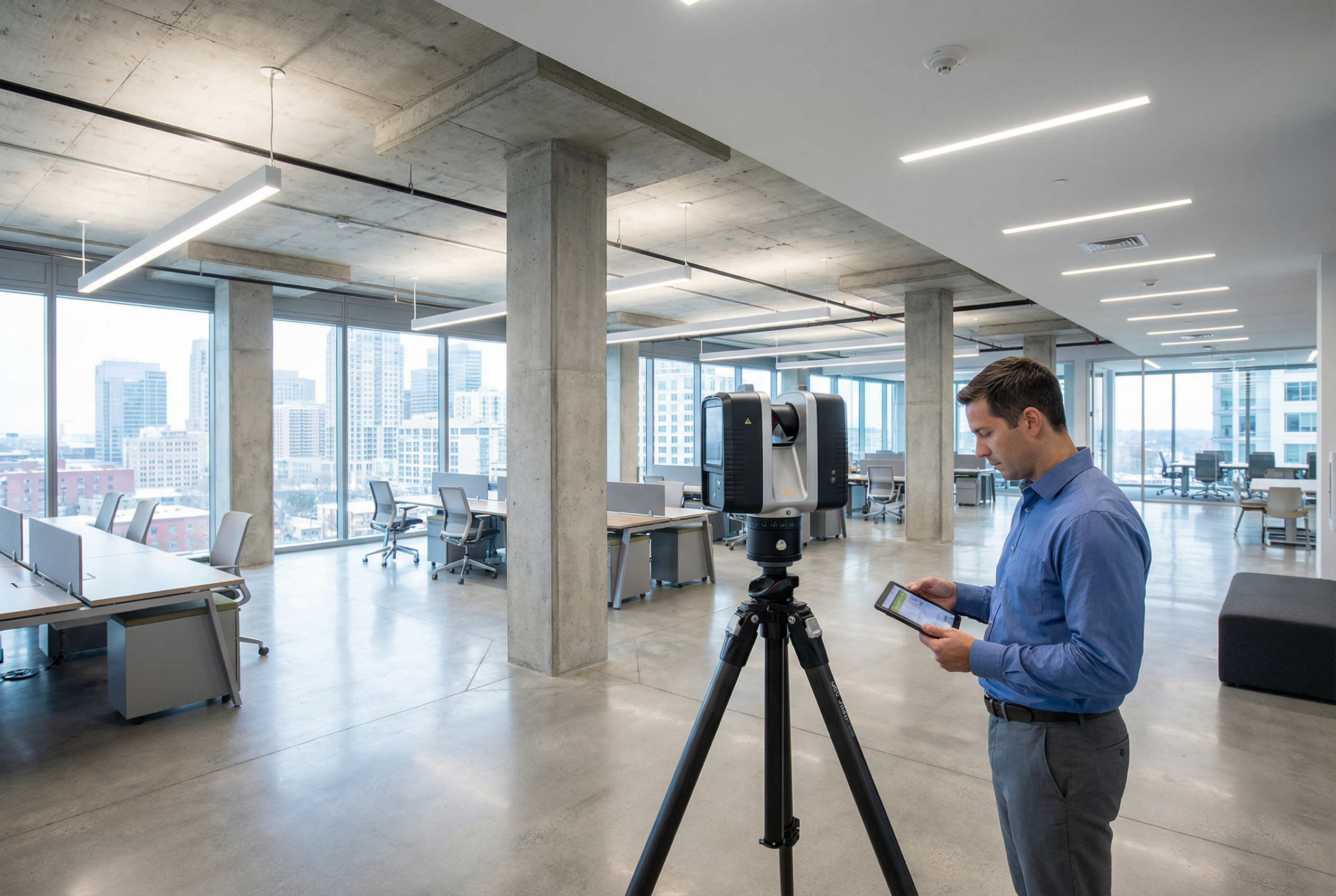
Robotic Imaging addresses these challenges through commercial property documentation that captures verified existing conditions at ±1/16 inch accuracy using the LEICA RTC 360 laser scanner, producing LOD 300 BIM models compatible with Revit and AutoCAD — the standard delivery formats expected by tenant architects and repositioning design teams. The same site mobilization that captures engineering-grade point cloud data also deploys the MATTERPORT Pro3 for 4K virtual tours, giving property management teams both the operational documentation and the leasing marketing tools they need without scheduling a second site visit.
Enterprise commercial real estate operators including JLL — the world's largest commercial real estate services firm — rely on this documentation approach across their managed portfolios. For property managers evaluating scan-to-BIM vendors, JLL's adoption signals enterprise-grade delivery confidence.
Ready to assess your property's documentation needs? Request a Property Documentation Assessment to discuss your TI season timeline or repositioning scope.
Tenant Improvement Support: Eliminating Design Delays and Allowance Disputes
Tenant improvement scanning solves two distinct problems in the TI project lifecycle: design acceleration at the front end and dispute prevention at lease commencement.
Design Acceleration
When a tenant executes a lease, their architect cannot begin design until existing conditions are verified. Without landlord-provided as-built documentation, that verification falls to the tenant's team — a process involving multiple field visits, manual measurements, and coordination with building management for MEP access. This process routinely adds four to six weeks to a TI schedule before a single design decision is made.
When Robotic Imaging delivers a LOD 300 BIM model within 10-14 business days of scan capture, the tenant's architect receives a verified Revit (.rvt) or AutoCAD (.dwg) model covering floor plate geometry, column grid dimensions, existing MEP system locations, ceiling heights, window mullion positions, and structural elements. Design begins immediately. The landlord who provides this documentation shortens the tenant's path to occupancy — a material advantage in competitive lease markets where tenants evaluate total time-to-occupancy alongside rent economics.
Dispute Prevention
TI allowance disputes typically arise from a single source: a discrepancy between what the lease assumed about existing conditions and what field conditions actually presented when construction began. If the as-built drawings showed a 9-foot ceiling height and construction discovered 8 feet 4 inches due to an undocumented beam, the cost delta lands in dispute.
±1/16 inch accuracy documentation captured at lease commencement creates an undisputable existing conditions baseline. Every dimension, every system location, every structural element is recorded in the point cloud with verification that can be revisited at any point in the TI process. Property managers using this approach convert potential dispute exposure — which can reach $50,000–$500,000+ in TI allowance disagreements on large floor plates — into a documented record that protects both parties.
What LOD 300 delivers for TI coordination:
- Floor plate geometry accurate to ±1/16 inch for space planning and partition layout
- Column grid documentation for structural coordination
- Ceiling height verification at multiple points across the floor plate
- MEP system inventory including HVAC equipment, duct routing, electrical panels, and plumbing locations
- Window and curtain wall dimensions for daylighting calculations
- File delivery in Revit (.rvt), AutoCAD (.dwg), and point cloud formats (RCS, RCP)
Tenant improvement services at this documentation level give property managers a repeatable framework: scan each floor plate before TI season opens, deliver models to prospective tenants' architects as part of the leasing package, and enter every TI negotiation with a verified existing conditions baseline already on the table.
Building Repositioning and Capital Planning Documentation
Building repositioning documentation is the critical first step in a Class B-to-A upgrade program — and the step most often undertaken with inadequate existing conditions data. Repositioning feasibility depends on accurate knowledge of existing building systems: mechanical capacity, electrical infrastructure, floor-to-floor heights, core and shell geometry, and the physical constraints that determine what improvements are achievable within the building envelope.
When repositioning scope is defined against drawings that haven't been field-verified since original construction, design teams spend the first phase of a capital project reconciling reality against the plan. System replacements get redesigned when actual equipment dimensions don't match drawing records. Lobby renovation concepts get repriced when ceiling height assumptions prove incorrect. Phased improvement timelines shift when MEP infrastructure conflicts surface mid-construction.
Robotic Imaging's scan-to-BIM process produces the building-wide documentation that repositioning design teams need to proceed with confidence:
System inventory at LOD 300 captures all existing MEP infrastructure — HVAC equipment capacities and duct routing, electrical panel locations and capacity documentation, plumbing infrastructure — giving mechanical and electrical engineers verified existing conditions to design against rather than assumed conditions.
Core and shell geometry documents the building envelope, floor-to-floor heights, structural bay dimensions, vertical circulation cores, and facade characteristics that define repositioning constraints. Lobby renovation concepts, amenity floor conversions, and common area redesigns all begin from this documented baseline.
Phased capital planning is enabled by having a complete building documentation model that can be queried for each repositioning phase. Rather than re-mobilizing survey teams for each phase, the initial scan-to-BIM model serves as the persistent existing conditions reference — updated as improvements are completed.
The ROI framework for repositioning documentation is straightforward: accurate scope definition at the outset of a capital program reduces design iteration cost, eliminates construction RFIs driven by existing conditions surprises, and compresses the overall improvement timeline. The scan-to-BIM investment — typically $15,000–$50,000 for a full building depending on complexity — is a rounding error against the capital programs it supports, and against the cost of a single major scope change caught after construction has begun.
Lease Velocity Acceleration with Integrated Virtual Tours

The MATTERPORT Pro3 virtual tour captured during the same site mobilization as the LEICA RTC 360 point cloud scan creates a leasing marketing deliverable that operates independently of the engineering documentation.
Virtual Tour Applications for Leasing
A 4K MATTERPORT Pro3 virtual tour embedded in a property listing allows prospective tenants and their brokers to navigate the space before scheduling a physical tour. For out-of-market tenants evaluating multiple markets simultaneously, a navigable 3D virtual tour compresses the evaluation cycle. For national tenants working through tenant representation brokers, properties with professional virtual tours reach the shortlist faster than properties with static photography.
The same tour that supports leasing marketing also documents the floor plate accurately for space planning purposes. Unlike Matterport's standard real estate photography application — which provides visual tours without engineering-grade dimensional accuracy — the combined Robotic Imaging mobilization delivers a Matterport tour alongside an LOD 300 BIM model from the same scan session. Prospective tenants receive both the visual walkthrough for site selection and the accurate floor plan dimensions for test-fit planning.
Accurate Floor Plans as a Leasing Differentiator
Properties that provide verified floor plan documentation as part of the leasing package differentiate on a dimension that most landlords overlook. When a tenant's space planner can import a verified Revit or CAD floor plan rather than re-measuring from scratch, the test-fit process accelerates. Properties that make this process frictionless close leases faster — reducing vacancy carrying costs that compound at $25–$75+ per square foot per month depending on market.
Broker Coordination
Virtual tour links can be distributed directly to tenant representation brokers, embedded in listing platform profiles, and integrated into property marketing materials without requiring broker coordination for physical access. For properties with multiple vacancies or full-floor availabilities, a suite of Matterport tours indexed to the building's floor stack gives brokers a self-service tool that reduces coordination burden on property management staff.
Occupancy Optimization and Portfolio Documentation
Property management BIM models serve ongoing space management functions beyond the initial TI and leasing applications. Once an LOD 300 building model exists, it becomes the reference layer for occupancy optimization decisions.
Space utilization analysis built on verified floor plate documentation identifies where tenant density is below market, where common area configurations limit leasable area, and where repositioning phasing should prioritize based on actual square footage impact. Property managers with accurate documentation can model reconfiguration scenarios — converting underutilized amenity space, adding conference suite product, subdividing large floor plates for multi-tenant configurations — against verified existing conditions rather than assumed dimensions.
For portfolio documentation, Robotic Imaging's project platform provides a centralized dashboard where property managers overseeing 5–50 properties can access documentation for all assets from a single interface. Nationwide US coverage and 24/7 scheduling mean documentation can be initiated simultaneously across a portfolio without waiting for regional availability. Consistent LOD 300 documentation across portfolio assets enables capital comparison across properties — identifying which buildings carry the highest deferred maintenance risk, which have the most repositioning potential, and how capital should be allocated across the portfolio in a given cycle.
Property Marketing Applications
Property management BIM documentation extends into marketing channels beyond virtual tours. Accurate floor plans derived from LOD 300 models support listing platform uploads, broker package materials, and property website floor plan overlays. Rendered visualizations developed from the BIM model support repositioning marketing — showing prospective anchor tenants what a redelivered floor plate will look like based on the documented existing conditions.
360° virtual tour embeds integrate directly into property website listing pages, CoStar and LoopNet profiles, and broker email marketing. The MATTERPORT Pro3 platform generates shareable links compatible with all major listing platforms, enabling property management teams to deploy virtual tour content through existing marketing workflows without technical integration work.
For lease space documentation supporting tenant-facing marketing, accurate floor plan graphics extracted from the BIM model provide higher quality materials than redlined PDF scans — an upgrade that signals property quality to prospective tenants before they set foot in the building.
Frequently Asked Questions
What is scan-to-BIM for commercial real estate property managers? Scan-to-BIM for property managers converts laser scan point cloud data into LOD 300 BIM models documenting existing conditions — floor plates, column grids, ceiling heights, and MEP systems — used for tenant improvement coordination, building repositioning scope definition, and leasing documentation. Delivered in 10-14 business days with file formats compatible with tenant architects' Revit and AutoCAD workflows.
How does laser scanning support tenant improvement projects? Laser scanning provides verified as-built documentation that tenant architects use as the design baseline, eliminating field verification delays and creating a defensible existing conditions record at lease commencement that prevents TI allowance disputes when field conditions are questioned.
What is building repositioning documentation? Building repositioning documentation is an LOD 300 BIM model capturing a commercial building's complete core and shell geometry, MEP system inventory, and structural conditions — used to accurately scope Class B-to-A upgrade programs, phase capital improvements, and support repositioning feasibility analysis before design investment begins.
How do 3D virtual tours help lease commercial office space faster? MATTERPORT Pro3 4K virtual tours embedded in listing platforms and broker marketing materials allow prospective tenants to navigate available spaces remotely, compressing the site selection cycle and supporting test-fit planning through accurate dimensional reference from the same scan mobilization.
What LOD is needed for tenant improvement coordination? LOD 300 is the standard for tenant improvement coordination — providing sufficient dimensional accuracy and MEP system documentation for design development without the additional cost of LOD 400 fabrication-level detail. LOD 300 models include all elements a tenant's architect needs to begin partition layout, lighting design, and MEP coordination.
How long does it take to get as-built documentation for a commercial building? Robotic Imaging completes field capture in 2-3 days for most commercial floor plates, with total delivery of LOD 300 BIM models and MATTERPORT Pro3 virtual tours in 10-14 business days from scan capture — compared to 3-6 weeks for traditional manual survey and CAD documentation methods.
For property managers facing an active TI season, a repositioning initiative, or a competitive leasing environment, documentation is the operational foundation everything else builds on. Accurate existing conditions eliminate the field verification delays that push tenant occupancy dates back. Verified TI baselines eliminate the allowance disputes that consume legal and project management resources. And 4K virtual tours captured in the same site visit as the engineering documentation give leasing teams marketing tools that cost nothing extra to produce.
Robotic Imaging's property manager scan-to-BIM service delivers all three from a single mobilization — LOD 300 BIM models compatible with tenant architects' workflows, MATTERPORT Pro3 virtual tours ready for broker distribution, and point cloud data archived for future capital planning reference. With 100M+ sq ft documented for enterprise CRE clients including JLL, and nationwide coverage enabling portfolio-wide deployment under a single vendor relationship, Robotic Imaging is the documentation partner built for commercial office property management at any scale.
Request a Property Documentation Assessment to discuss your TI timeline, repositioning scope, or leasing documentation needs. Ready to see what MATTERPORT Pro3 virtual tours look like for your asset? Schedule a Marketing Demo and we'll walk through virtual tour examples for comparable commercial office properties. Managing multiple assets? Contact Robotic Imaging to discuss a portfolio documentation program tailored to your capital planning cycle.