The As-Built Colorized LiDAR Point Cloud: New Applications for the Built World
Robotic ImagingJune 30, 2026
The As-Built Colorized LiDAR Point Cloud: New Applications for the Built World
A colorized LiDAR point cloud is a 3D dataset made of millions of XYZ-coordinate points captured by laser scanners, each assigned an RGB color value from overlaid photography. This produces a true-to-life, measurable digital replica of a physical space used across architecture, engineering, and construction.
What Is a Colorized LiDAR Point Cloud?
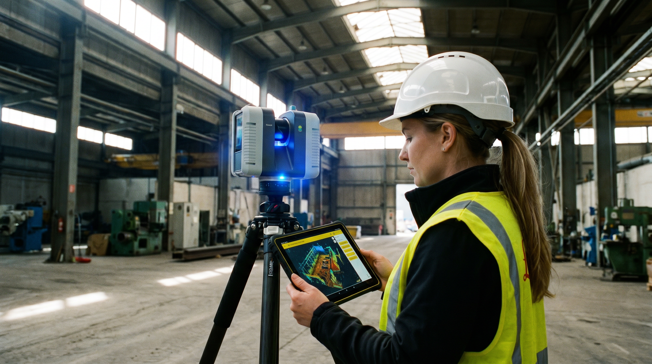
LiDAR stands for Light Detection and Ranging, a technology that fires laser pulses at a surface and measures the time it takes for light to return. Each pulse generates a single data point with a precise XYZ coordinate. When millions of these points are captured together, they form a point cloud — a dense, measurable representation of the physical world.
A standard point cloud contains only spatial data. A colorized LiDAR point cloud goes a step further by layering high-resolution photography over the scan data, assigning each point an RGB color value. The result looks and feels like a photograph but behaves like a measurable, three-dimensional model. Architects, engineers, and facilities teams can rotate it, measure it, and extract real-world dimensions directly from the file.
As-built accuracy standards vary by industry. In construction, an as-built dataset is typically expected to be accurate within 1/8 of an inch. In architecture, the accepted tolerance is closer to 1/4 of an inch. Both standards are well within the capability of modern terrestrial laser scanners, which is why colorized LiDAR point clouds have become the foundation for as-built documentation across the built environment.
How Is a Colorized LiDAR Point Cloud Used in Architecture and Construction?

In architecture, engineering, and construction workflows, a colorized LiDAR point cloud serves as the verified source of truth for existing conditions. Design teams use it to confirm that a space matches its original drawings, identify discrepancies before construction begins, and reduce the rework that comes from relying on outdated or inaccurate plans.
Civil engineers rely on point cloud data to document large topographies quickly and accurately, replacing slower manual survey methods. Commercial real estate teams use colorized point clouds to evaluate how existing buildings can be repositioned for new uses — converting retail space into industrial, logistics, or mixed-use development, for example. Capturing an accurate as-built record is the fastest way to begin that evaluation process, because every dimension, wall, and obstruction is already documented in three dimensions.
Robotic Imaging captures colorized LiDAR point clouds for Fortune 500 client programs across hundreds of sites nationwide, supporting renovation planning, facilities management, and pre-construction design. Field capture is completed 50–80% faster than traditional manual surveying, with final deliverables typically ready in 10–14 business days.
Suggested reading: Learn how this data feeds into building design in our guide to laser scanning's role in BIM, or explore our Scan-to-BIM service page to see how point clouds become design-ready models.
What Software Is Used to View Point Cloud Files?
Point cloud files are large and require specialized software to open, navigate, and extract data from them. The most common formats include RCS and RCP (Autodesk ReCap Pro), E57 (an open, vendor-neutral format), and LAS (common in surveying and GIS applications). Each format serves a different purpose depending on the software ecosystem a team is using.
Autodesk ReCap Pro is the industry standard for managing and lightly editing point cloud data before it's imported into design software. From there, point clouds are typically linked into Revit for architectural and MEP modeling, AutoCAD for 2D drafting, or NavisWorks for coordination and clash detection across multiple building systems. Viewing software ranges from free, lightweight viewers for simple walkthroughs to full design suites for teams building complete BIM models on top of the scan data.
What Is the Difference Between a Point Cloud and a BIM Model?
A point cloud is raw, unstructured measurement data — it shows exactly what exists, but it doesn't understand what it's looking at. A wall is just a dense cluster of points, not an object with properties like material, thickness, or fire rating. A BIM model, by contrast, is built by modeling intelligent objects — walls, doors, ductwork, structural columns — on top of the point cloud, at a defined Level of Development such as LOD 200, LOD 300, or LOD 350.
In practice, the point cloud is the evidence, and the BIM model is the interpretation. Scan-to-BIM teams use the colorized point cloud as a precise reference layer, tracing and modeling each building element to match real-world conditions within a fraction of an inch. This is why accurate point cloud capture is the critical first step — every downstream model, drawing, or facilities database depends on how well that initial scan was captured.
Why Does Color Data Matter in a LiDAR Point Cloud?
Color transforms a point cloud from an abstract measurement dataset into something stakeholders can actually interpret without specialized training. A facilities manager reviewing an uncolorized scan sees a gray cluster of dots. The same manager reviewing a colorized LiDAR point cloud sees recognizable finishes, signage, equipment, and damage — information that speeds up decision-making and reduces miscommunication between field teams and design teams.
Color data also supports historical preservation projects, where documenting the exact existing appearance of a structure matters as much as its dimensions. Combined with high point density, colorization allows these archives to be revisited and reused years later for renovation, restoration, or compliance documentation, without needing to remeasure the building from scratch.
What Challenges Come With Managing Point Cloud Data?
Despite its value, point cloud data presents practical challenges that teams need to plan for:
- File size and computing requirements: Colorized scans of large facilities can reach tens of gigabytes, requiring adequate hardware and storage.
- Accuracy from field to final file: Capture methodology, scanner calibration, and registration quality all affect final accuracy.
- Software compatibility: Not every design platform handles every point cloud format natively, which can create friction during handoff.
- Modeling expertise: Translating a point cloud into a usable BIM model requires trained technicians who understand both the data and the design intent.
Firms that solve these four challenges position themselves to apply point cloud data confidently across pre-construction, surveying, architecture, facilities management, and leasing decisions.
See How Point Cloud Data Becomes a Usable Model
Robotic Imaging captures colorized LiDAR point clouds and converts them into design-ready Scan-to-BIM and Scan-to-CAD deliverables for teams nationwide.
Explore Our ProcessFrequently Asked Questions About Colorized LiDAR Point Clouds
What is a colorized LiDAR point cloud?
A colorized LiDAR point cloud is a 3D dataset of XYZ-coordinate points captured by laser scanners, with each point assigned an RGB color value from overlaid photography. It creates a measurable, photorealistic digital replica of a physical space used for design, construction, and facilities documentation.
How is a point cloud used in architecture?
Architects use point clouds as a verified record of existing building conditions before starting a design or renovation project. The data confirms accurate dimensions, identifies discrepancies from original drawings, and serves as the base layer for modeling walls, ceilings, and structural elements in BIM software like Revit.
What software is used to view point cloud files?
Common software includes Autodesk ReCap Pro for managing and viewing RCS and RCP files, and design platforms like Revit, AutoCAD, and NavisWorks for working with point clouds alongside building models. E57 and LAS formats are widely supported across surveying and GIS software as well.
What is the difference between a point cloud and a BIM model?
A point cloud is raw measurement data showing exactly what exists, without identifying what the objects are. A BIM model is built by modeling intelligent, named objects — walls, doors, MEP systems — directly on top of the point cloud at a defined Level of Development, typically LOD 200 through LOD 350.
All pricing, delivery timelines, accuracy specifications, and client references reflect verified data from roboticimaging.com. Robotic Imaging is ISO 27001 certified and SOC 2 Type II compliant.