What Is Robotic Imaging? LiDAR Scanning, Scan-to-BIM & AI Facility Management Explained
Robotic ImagingMay 15, 2026
What Is Robotic Imaging? LiDAR Scanning, Scan-to-BIM & AI Facility Management Explained
Here’s a situation that plays out constantly across the construction and retail industry. A Director of Facilities has 200 stores scheduled for a renovation program. Her design team is ready to go. The general contractor is priced and standing by. The only thing blocking the entire project from moving is this: nobody has an accurate set of drawings for any of the buildings.
The original as-builts are from the 1990s, stored as PDFs that were scanned from hand-drawn documents. Half of them don’t match what’s actually in the field — walls in the wrong place, ceiling heights wrong by several inches, MEP routing that was changed three renovations ago and never documented. Every site visit the architects have to make costs $1,500 or more. With 200 stores, that’s a $300,000 problem before a single design decision has been made.
This is the exact problem Robotic Imaging was built to solve.
What Is Robotic Imaging?
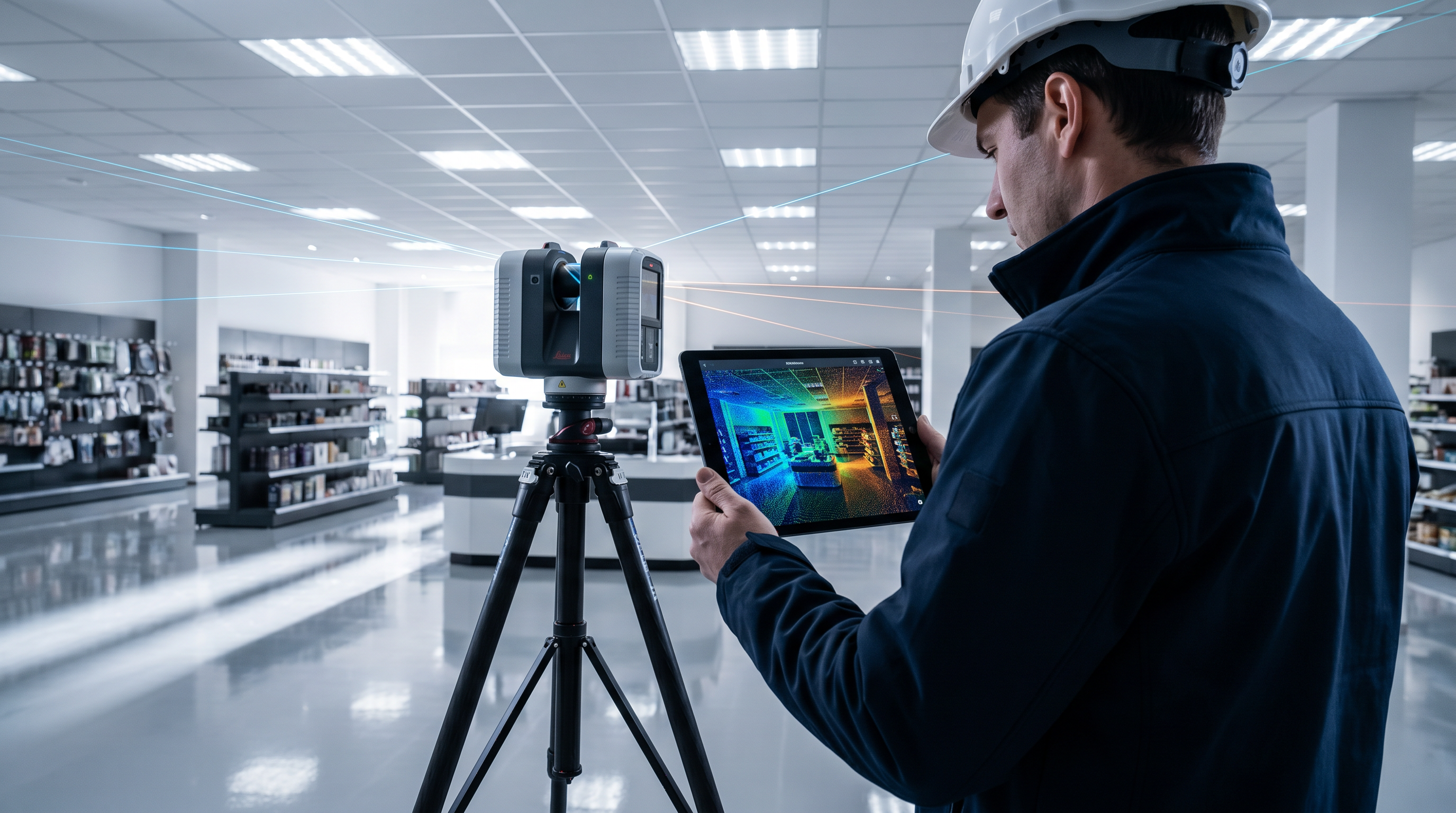
Robotic Imaging is a Philadelphia-based company that has been digitizing the built environment since 2017. At its core, it does two things that most companies treat as entirely separate businesses: it captures physical buildings with precision LiDAR laser scanning hardware, and it runs a cloud-based platform that turns all that captured data into living, searchable, AI-powered asset intelligence.
The scanning side delivers Scan-to-BIM models, Scan-to-CAD drawings, virtual walkthroughs, and drone documentation — with certified technicians dispatched nationally within 2–3 days, turning around complete deliverables in 10–14 business days at ±2–4mm accuracy. The platform side — RI Capture, RI Facilities, and the web dashboard — keeps that data useful long after the scan is done, connecting field teams, facility managers, vendors, and executives to the same source of truth.
Walmart, 7-Eleven, Kroger, CVS, T-Mobile, Nordstrom, Foot Locker, Ross, Lululemon, AutoZone, GoPuff, Greystar, Delta Air Lines, JLL, and more than a dozen other Fortune 500 brands have trusted Robotic Imaging with their documentation programs. To date, the company has documented over 100 million square feet of commercial space.
The Scanning Services: What Gets Captured and How
Scan-to-BIM: When You Need a Model That Thinks
Scan-to-BIM is the process of converting raw laser scan data — a dense cloud of millions of measured points — into an intelligent 3D model in Autodesk Revit. Unlike a PDF or even a CAD file, a BIM model understands what it contains. Walls are walls. Columns are structural elements. Ductwork belongs to the HVAC system. Every element carries data, not just geometry.
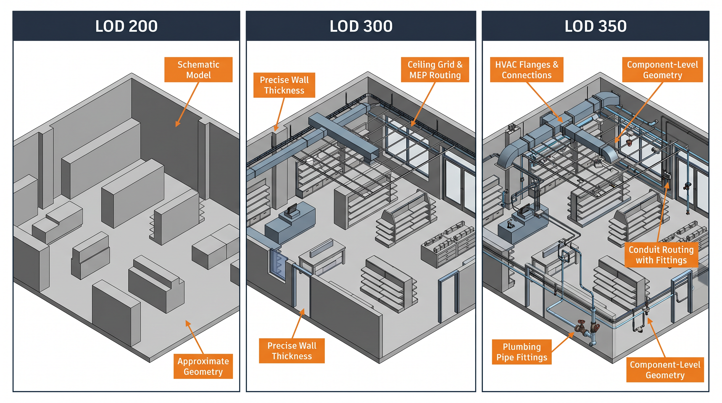
Robotic Imaging delivers Scan-to-BIM models at four levels of detail, defined by the AIA’s Level of Development (LOD) specification:
LOD 200 is the starting point. Elements are represented with approximate geometry — enough to understand spatial relationships, plan renovations, and estimate costs, but not enough to coordinate construction details. Think of it as a very accurate sketch of the building. The tolerance is ±1/4 inch from the point cloud, and it’s typically the right choice for early-stage retail rollout planning or portfolio documentation.
LOD 300 moves into construction precision. Every wall, beam, door, and system is modeled at its exact location, size, and orientation — the level architects and MEP engineers need to actually design from. This is where design-build clashes get caught before they become change orders on site.
LOD 350 is where the model starts showing not just what’s there, but how things connect. An HVAC duct’s connection plates, a structural column’s anchor bolts, exactly how plumbing routes through a concrete wall — all of it modeled. For complex renovation projects, asset management programs, or facilities that need to be maintained digitally over years, LOD 350 is the standard that makes downstream work possible.
LOD 400 is available for specialist fabrication and installation documentation on request.
Scan-to-CAD: Accurate 2D Drawings Without the Headache
Not every project needs a full BIM model. Sometimes what a design team needs is a clean, accurate set of 2D drawings they can actually work from — floor plans, reflected ceiling plans, elevations, sections, MEP routing documentation. Robotic Imaging’s Scan-to-CAD service delivers exactly that, extracted directly from point cloud data rather than from a tape measure and a clipboard.
Deliverables come in .DWG, .DXF, and .PDF formats, layered and dimensioned, compatible with AutoCAD, Revit, Navisworks, and the rest of the AEC software stack. Pricing starts at $0.19 per square foot — making it one of the most cost-accessible paths to reliable as-built documentation for multi-site programs.
LiDAR Laser Scanning: The Hardware That Makes It Possible
Everything starts with the scanner. Robotic Imaging deploys a fleet of purpose-built LiDAR hardware, matched to what a project actually needs:
| Scanner | Capture Speed | Range | Best Application |
|---|---|---|---|
| LEICA RTC 360 | 2,000,000 pts/sec | 130m | Large commercial spaces, high-detail BIM |
| LEICA BLK 360 | 680,000 pts/sec | 60m | Retail interiors, tight spaces |
| LEICA ScanStation P50 | 1,000,000 pts/sec | 1,000m | Infrastructure, large exterior sites |
| MATTERPORT Pro3 | 100,000 pts/sec | 20m | 3D walkthroughs, VR documentation |
| RI Capture App | Smartphone camera | On-device | Self-service asset capture |
Point cloud outputs are delivered in RCS, RCP, E57, and LAS formats — the standard formats that feed directly into Autodesk ReCap and the broader AEC software ecosystem.
360° Virtual Tours and Drone Services
For clients who need teams to walk a space remotely — during design reviews, pre-lease due diligence, or stakeholder presentations — Robotic Imaging produces Matterport-based 3D virtual walkthroughs that feel like being there. For exterior, roof, and large-site documentation, the company operates LiDAR drone surveys and photogrammetry captures that would take ground crews days to complete manually.
The Platform: Where the Data Lives and Works
This is where Robotic Imaging’s 2026 direction becomes clear. The scanning and modeling services have been the company’s foundation since 2017, but the platform is where it’s going — because a LiDAR scan is only as useful as what you can do with it six months later, and that’s where most scanning companies leave their clients stranded.
RI Capture and RI Facilities — Mobile Apps for the Field
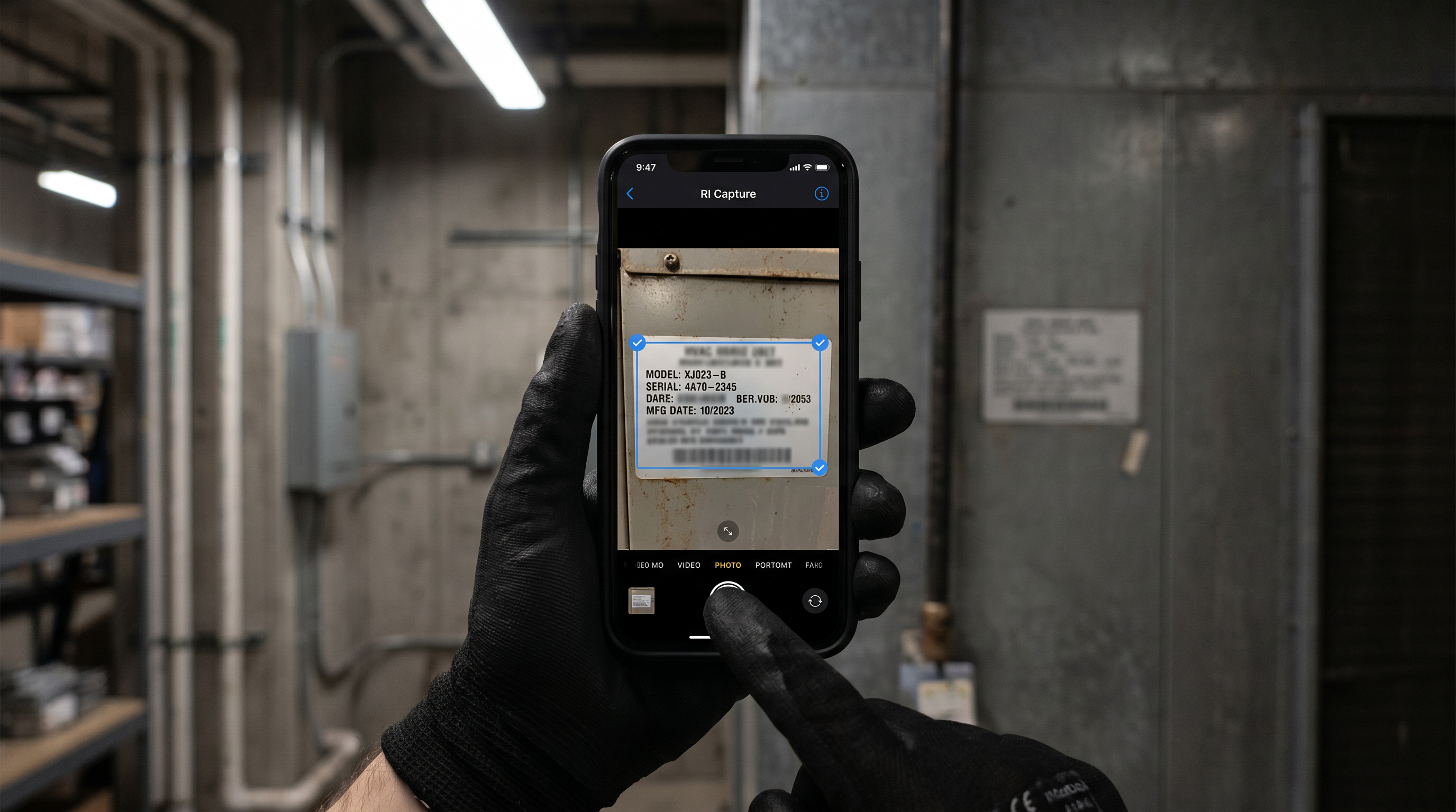
RI Capture (available free on iOS and Android) is designed for teams who need to document assets without flying in a specialist. A store manager walks the floor, photographs equipment, scans QR codes, and builds an asset registry from their phone. The app works fully offline — important in basement equipment rooms and concrete-walled back-of-house spaces where signal disappears — and syncs everything automatically when connectivity returns.
RI Facilities goes a level deeper: QR and barcode scanning, nameplate capture and verification, asset image documentation. It’s the tool that keeps a portfolio’s asset registry alive and accurate between professional scans, rather than letting it drift back toward the inaccurate state that triggered the documentation project in the first place.
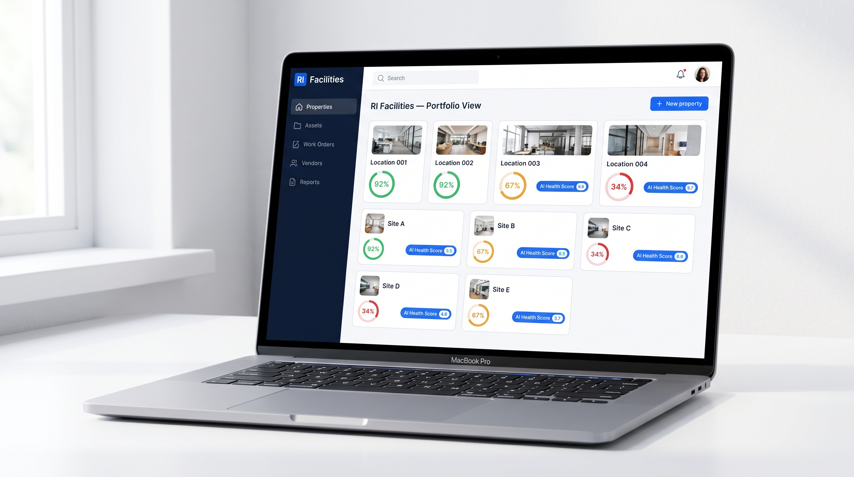
The Web Platform: Starter, Advanced, Enterprise
As of May 2026, Robotic Imaging’s web platform has three tiers built for different points in an organisation’s maturity with digital facility management.
Starter handles the fundamentals that teams reaching for spreadsheets and shared drives actually need: unlimited properties, asset management, team collaboration, photo and document storage, basic reporting, and CSV/PDF data export. It’s the foundation.
Advanced is where AI starts doing real work. The AI assistant lets facility teams ask questions about their portfolio in plain language. AI-generated property reports surface issues and patterns that would take hours to pull manually. AI recommendations flag where attention is needed before it becomes a problem. Voice-to-text features let field staff log notes without stopping to type.
Enterprise is the full suite: everything in Advanced, plus work order management with time tracking and approvals, vendor management with RFP workflows and portal access, handover checklists for construction-to-operations transitions, API access with real-time webhooks, SSO/SAML authentication for enterprise identity management, a dedicated customer success manager, and white label options for organisations embedding the platform under their own brand.
The platform runs on 25 AI edge functions — health scoring, failure prediction, anomaly detection, voice transcription, OCR extraction — all operating at sub-100ms response times via edge computing. It’s built on ISO 27001 certified, SOC 2 Type II compliant infrastructure, encrypted at rest and in transit, GDPR and CCPA compliant. Your data stays yours.
A live sandbox environment at sandbox.roboticimaging.com lets prospective clients explore the platform before committing to a conversation with sales — a genuinely rare offering in this category, and worth using.
The Delivery Timeline — and Why It Matters
Construction schedules don’t wait. When a design team is blocked on existing conditions data, every day costs money. Robotic Imaging’s end-to-end timeline looks like this:
- 2–3 days to schedule and dispatch certified field technicians
- 1–3 days on-site for field capture (most retail locations fall in the 1-day range)
- 3–5 days for point cloud processing and registration
- 7–10 days for BIM or CAD modeling
Total: 10–14 business days from scheduling to final deliverable. That’s 50–80% faster than traditional surveying and documentation alternatives — not a rounding difference but a schedule-changing one for programs where architects are standing by.
Who Actually Uses Robotic Imaging
The honest answer is: anyone who needs to know what’s actually in a building before they design, build, renovate, or manage it. In practice, that’s a fairly specific set of situations.
Retail construction and facilities teams planning renovation programs across dozens or hundreds of locations are the clearest fit. The 7-Eleven program is the most visible example — a systematic, multi-site documentation rollout that gave the brand accurate existing conditions data across 1,000+ stores. Dollar General’s planned 4,000-location deployment represents the same pattern at larger scale.
Architects and interior designers at firms like Nelson Worldwide use the models as the starting point for renovation design — eliminating the site verification trips that used to add weeks and thousands of dollars to a project’s pre-design phase. The scan becomes the floor plan; the BIM model becomes the coordination environment.
General contractors and construction managers use Robotic Imaging for pre-construction documentation (to catch scope surprises before they become change orders), progress monitoring, as-built verification, and punch list documentation. Getting accurate existing conditions at the start of a project is consistently one of the highest-ROI investments in construction.
Corporate real estate and asset management teams — JLL, Greystar, TravelCenters of America — use the platform for portfolio intelligence: capital planning visibility, M&A due diligence documentation, space planning, and ongoing facility management. The platform’s AI capabilities turn static documentation into something that actively helps manage a portfolio rather than just describing it.
What Clients Actually Say
The testimonials page lists dozens of clients. Three quotes from the homepage tell you what the experience is actually like.
Clifton B. from Delta Air Lines’ Corporate Real Estate team used Robotic Imaging’s scans to back-check design documents against the physical constraints of an airport build-out. His summary: “The team was easy to work with, got the job done quickly, and turned over the model fast.”
Sarah W., Associate Principal at Nelson Worldwide, had tried another scanning company first and had a bad experience. After switching: “We REALLY appreciate how responsive and professional the team is. We hope to continue to leverage your company’s services.”
Marc A., Senior Project Manager at Metalwërks, was blunter than most people are in a written testimonial: “Robotic Imaging provided the best set of deliverables we have ever seen.”
That last one gets quoted a lot — because it’s the kind of thing people don’t say unless they mean it.
Frequently Asked Questions
What is Robotic Imaging?
Robotic Imaging is a Philadelphia-based technology company combining premium LiDAR laser scanning services with an AI-powered facility management platform. It delivers Scan-to-BIM, Scan-to-CAD, 360° virtual tours, and drone documentation, plus RI Capture and RI Facilities mobile apps and a full web platform with AI assistant, work orders, and vendor management. Founded in 2017. 100M+ sq ft documented.
How accurate is the scanning?
±2–4mm point cloud accuracy depending on equipment. The LEICA RTC 360 — their primary scanner — hits ±2mm at 2,000,000 points per second. LOD 200 Scan-to-BIM models follow ±1/4 inch deviation from the point cloud. About 10x more accurate than traditional manual measurement.
How long does it take?
10–14 business days from scheduling to final deliverable. Field technicians can be on-site within 2–3 days of booking.
What does it cost?
Scan-to-CAD starts at $0.19 per square foot. Scan-to-BIM scales with LOD level and project size. Platform pricing is available on request through sales. Volume pricing applies for multi-location programs.
Does it work outside the US?
Yes. Robotic Imaging operates internationally across most countries, with 24/7 scheduling available through the mobile app.
Is the platform secure enough for enterprise?
ISO 27001 certified, SOC 2 Type II compliant, GDPR and CCPA compliant. Row-level security, end-to-end encryption. Built for Fortune 500 enterprise security requirements.
Can I try the platform before committing?
Yes. A live sandbox environment is accessible at sandbox.roboticimaging.com/demo — no sales call required to explore.
Where to Start
If the documentation gap between what your drawings say and what’s actually in your buildings is blocking a project, causing change orders, or making facility management harder than it should be, the path forward is straightforward.
Request a 15-minute demo — bring your project details and see what the right scope looks like for your situation.
Explore the live sandbox — walk through the platform yourself before talking to anyone.
Download RI Capture on iOS or Android — start capturing asset data today, no professional scan required.
View service samples and pricing — see LOD comparison examples and Scan-to-CAD deliverable formats before committing to anything.
The gap between a tape measure and a LEICA RTC 360 capturing 2,000,000 points per second is enormous. The gap between a static scan file and a living, AI-powered facility intelligence platform is larger still. Robotic Imaging sits at the intersection of both.