Point Cloud Registration | Professional QC | Robotic Imaging
Robotic ImagingJune 29, 2026
Point Cloud Registration: Methods, Standards, and Quality Control
Point cloud registration is the process of aligning multiple individual scan positions into a single, unified coordinate system. Accuracy is measured by RMSE per scan station and validated before BIM modeling begins. When performed with survey-grade equipment such as the LEICA RTC 360 at ±2mm, point cloud registration forms the quality foundation for every LOD 300–350 deliverable.
For Survey Coordinators evaluating laser scanning providers, registration is not a background process — it is the single most consequential quality gate in any Scan-to-BIM workflow. A scanner that captures at ±2mm instrument accuracy can still produce an unusable deliverable if registration error accumulates unchecked across a multi-floor traverse. This article explains how point cloud registration works, what accuracy standards govern acceptable outcomes, and how Robotic Imaging's end-to-end in-house workflow maintains registration quality across Fortune 500 client programs spanning hundreds of sites.

What Is Point Cloud Registration?
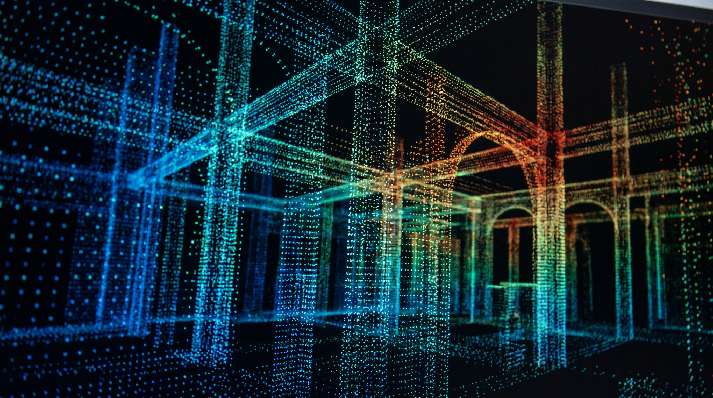
Point cloud registration is the computational process of transforming multiple discrete scan positions — each representing a partial view of a physical space — into a single, cohesive three-dimensional coordinate system. Each scan station captures geometry within its line of sight. No single station captures an entire building. Registration mathematically stitches those individual captures into one unified point cloud that represents the complete as-built environment.
The quality metric that governs registration is RMSE — root mean square error — measured per scan station. RMSE quantifies the deviation between each scan's position after alignment and its theoretical best-fit position within the registered cloud. A low RMSE per station indicates a tight, reliable alignment. A high RMSE indicates accumulated error that will propagate directly into any downstream deliverable, including LOD 300–350 BIM models and as-built CAD drawings.
Registration is not a post-processing afterthought. It is the quality foundation on which every Scan-to-BIM deliverable rests. For teams procuring laser scanning services, understanding how a provider performs and validates registration is as important as knowing what scanner they deploy in the field.
Target-Based vs. Cloud-to-Cloud Point Cloud Registration Methods
Two primary methods are used to perform point cloud registration in commercial AEC applications: target-based registration and cloud-to-cloud registration. A hybrid approach combining both is increasingly standard for complex, multi-floor, or MEP-intensive projects.
Target-Based Registration
Target-based registration uses physical reference objects — typically spherical targets or checkerboard flat targets — placed at precisely measured locations throughout the scan environment. Each scanner station observes multiple targets within its field of view. The registration software identifies and matches these common targets across adjacent scan positions, anchoring the alignment to physical control geometry. Because targets provide discrete, unambiguous tie points, this method achieves the highest achievable registration accuracy and is the preferred approach for LOD 300–400 deliverables, long traverses across multiple floors, and spaces with complex or repetitive geometry.
Cloud-to-Cloud Registration (ICP)
Cloud-to-cloud registration uses the Iterative Closest Point (ICP) algorithm to align overlapping scan positions by matching raw surface geometry — no physical targets required. The algorithm iteratively minimizes the distance between corresponding points in adjacent scans until an optimal alignment is achieved. This method is faster to deploy in the field because target placement time is eliminated. However, its accuracy depends heavily on surface variation within the overlap zone. Featureless surfaces — smooth walls, glass, uniform floors — provide insufficient geometry for reliable ICP convergence, increasing registration error risk in those environments.
Hybrid Registration
The hybrid approach combines target-based control points with cloud-to-cloud refinement. Targets provide coarse, reliable anchors; ICP refines the alignment at the surface level. This combination delivers the highest confidence registration outcomes and is the method Robotic Imaging applies to multi-floor commercial, retail, and industrial programs where both accuracy and field efficiency are required.
| Method | Accuracy | Field Speed | Best Application |
|---|---|---|---|
| Target-based registration | Highest — anchored to physical control | Slower (target setup time required) | LOD 300–400 deliverables, complex geometry, long traverses |
| Cloud-to-cloud (ICP) | High — surface-dependent | Faster (no target placement) | Simple geometry, uniform surfaces, large open areas |
| Hybrid (targets + ICP) | Highest confidence | Balanced | Multi-floor commercial, MEP-intensive spaces, enterprise programs |
What Accuracy Standards Govern Point Cloud Registration Quality?
Point cloud registration accuracy is evaluated through two primary metrics: station-level RMSE and traverse closure error. Both must fall within defined tolerances before a registered point cloud is considered fit for BIM modeling.
Station-Level RMSE: RMSE is calculated for each scan station during registration processing, typically within Autodesk ReCap Pro. It represents the deviation between the station's computed alignment position and the positions of its matched tie points or target centroids. For LOD 300 BIM deliverables — which require exact geometry, accurate opening dimensions, and spatial relationships between building elements — station-level RMSE should generally not exceed ±2–3mm. This tolerance is achievable with the LEICA RTC 360, which carries an intrinsic accuracy specification of ±2mm.
Traverse Closure Error: In a multi-station traverse — a sequence of scan positions that loops through a building and closes back on itself or on a known control point — closure error measures how precisely the registered cloud closes at the end of the traverse. A traverse that fails to close within tolerance indicates accumulated registration error that cannot be corrected retroactively through BIM modeling. Closure error is the system-level validation that station RMSE alone cannot provide.
LOD Standards and Registration Tolerance: The relationship between registration accuracy and LOD deliverable requirements is direct. LOD 200 deliverables represent approximate geometry and can tolerate higher registration error. LOD 300 deliverables require exact geometry with accurate dimensions and opening locations — registration error becomes a limiting factor. LOD 350 adds interface and connection detail, demanding that registration be tight enough to support coordination between disciplines. Any registration error above the LOD-appropriate threshold will propagate into the BIM model as dimension deviations that require costly rework.
How Scanner Hardware Affects Point Cloud Registration Quality
The intrinsic accuracy of the scanner hardware used in the field sets an absolute ceiling on achievable registration quality. No registration software — not even Autodesk ReCap Pro with optimized settings — can recover accuracy that was not captured in the field. Equipment selection is therefore a registration decision, not just a capture decision.
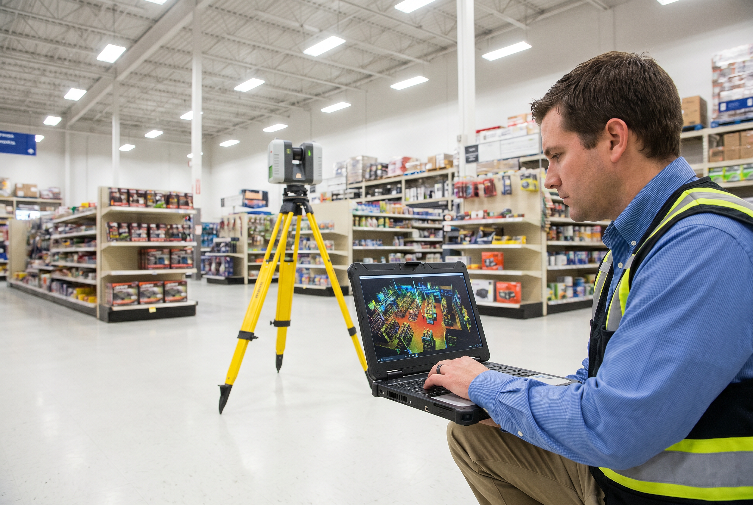
LEICA RTC 360: Capturing at 2,000,000 points per second with ±2mm accuracy across a 130m range, the LEICA RTC 360 is the primary instrument Robotic Imaging deploys for commercial and industrial projects requiring LOD 300–350 deliverables. Its combination of high point density, long range, and sub-3mm accuracy supports reliable target detection and ICP convergence even in geometrically complex environments. IP54 protection extends deployment capability to construction sites and industrial facilities.
LEICA BLK 360 G2: At 360,000 points per second and ±4mm at 10m, the BLK 360 G2 is suited for supplementary capture in confined spaces or areas requiring compact scanner deployment. Its lower accuracy specification makes it appropriate for LOD 200–300 applications or supplemental infill scanning within a primary RTC 360 capture program, where its data is anchored by the higher-accuracy stations.
LEICA BLK2GO: The BLK2GO is a mobile walk-through scanner capturing at 420,000 points per second using SLAM (Simultaneous Localization and Mapping) algorithms for continuous mobile registration. It is well-suited to corridor capture, stairwells, and complex circulation geometry where static tripod setups are impractical. Its registration approach differs fundamentally from static scanner workflows — SLAM-based registration accumulates drift over distance and requires careful control point integration for large-scale programs.
LEICA ScanStation P40/P50: The ScanStation series delivers survey-grade accuracy for engineering and survey applications requiring the highest-precision control networks. These instruments are deployed for projects where a formal survey traverse is required before or alongside the laser scanning workflow — establishing the coordinate control framework into which all other scan data is registered.
The Scan Registration Workflow: From Field Capture to Aligned Point Cloud
A complete point cloud registration workflow follows a defined sequence from field planning through final export. Understanding each phase helps Survey Coordinators evaluate whether a provider's stated timeline and quality claims are achievable.
Step 1: Station Planning and Control Network Design
Before the first scan is captured, the field team designs a station layout that ensures sufficient overlap between adjacent positions and establishes target placement geometry that supports accurate multi-station registration. Control network design — defining the traverse path through the building — determines whether closure error will be manageable at the end of the project.
Step 2: Target Placement and Field Capture
Spherical or checkerboard targets are positioned at locations visible from multiple adjacent scan stations. The scanner is positioned at each planned station, targets are confirmed in the field of view, and capture is initiated. For most commercial projects, field capture completes in 2–3 business days depending on building size and complexity.
Step 3: Import and Registration in Autodesk ReCap Pro
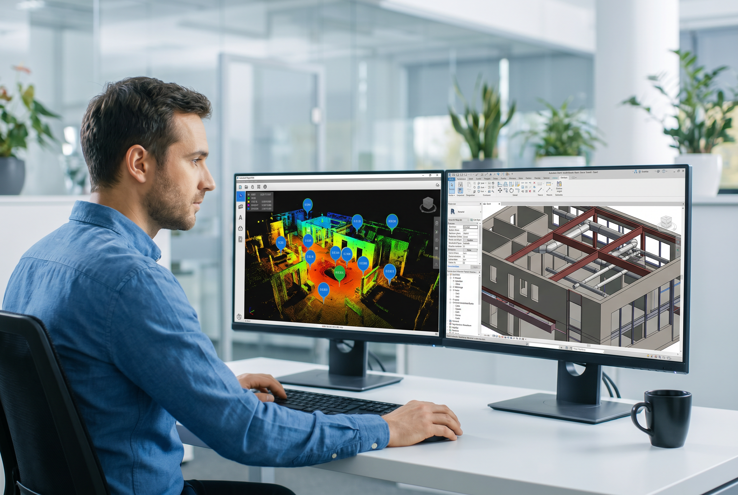
All scan data is imported into Autodesk ReCap Pro, where the registration workflow begins. Target centroids are identified and matched across adjacent stations. Cloud-to-cloud refinement is applied where appropriate. ReCap Pro computes station-level RMSE for each alignment and generates a registration report that documents error at each station.
Step 4: Residual Review and Error Correction
The registration technician reviews RMSE values for each station and identifies any stations where residuals exceed tolerance. Poor tie point geometry, missed targets, or insufficient overlap are corrected at this stage — either by re-running registration with adjusted parameters or, in cases of high error, flagging the need for supplemental field capture. This processing phase spans 3–5 business days.
Step 5: Final Alignment and Export
Once all stations pass residual review, the complete registered point cloud is exported in the project-specified format — RCS/RCP for Revit-native workflows, E57 for software-agnostic delivery, LAS for geospatial or drone-integrated programs. The registered cloud is then transferred to the BIM modeling team, which operates within the 7–10 business day modeling phase. Total project delivery from first day of field capture to final Revit or CAD deliverable: 10–14 business days.
Scan Overlap, Station Density, and Registration Error Management
Scan overlap is the percentage of captured geometry shared between two adjacent scan stations. It is the primary field variable that determines whether cloud-to-cloud registration can converge reliably and whether target-based tie points have sufficient redundancy to constrain the alignment.
Industry practice for commercial scan programs targets a minimum of 30% overlap between adjacent stations. Below this threshold, the shared geometry available for ICP matching is insufficient to produce reliable convergence, particularly in spaces with limited surface variation. In practice, 40–60% overlap is preferable in complex environments — MEP-intensive ceiling spaces, irregular floor plates, or historic structures where geometry changes significantly between stations.
Station density — the number of scan positions per unit area — must be calibrated to the project geometry. Open warehouse or retail floor plates may require one station per 20–30 metres of traverse. Spaces with significant obstruction — racking systems, mechanical equipment, partitioned offices — require denser station placement to maintain adequate overlap through occluded areas. Insufficient station density is one of the most common sources of registration error accumulation in commercial scan programs, and it is a field planning failure, not a software limitation.
Error accumulation across a traverse is compound: each station's residual adds to the cumulative error budget. A 10-station traverse where each station carries 3mm of RMSE does not produce a 3mm registered cloud — it can produce significantly more, depending on traverse geometry. Closure error at the end of the traverse quantifies this accumulation and is the field-to-processing handoff metric that determines whether remedial capture is needed before registration processing begins.
Quality Control After Point Cloud Registration: Verification Before BIM Modeling
Passing registration is not the same as delivering a quality-verified point cloud. A registered cloud that passes ReCap Pro's automated RMSE computation must still be visually inspected, format-validated, and reviewed against project deliverable specifications before BIM modeling begins. Releasing an unvalidated registered cloud to a BIM modeling team is one of the most expensive errors in a Scan-to-BIM workflow — model rework driven by registration error is discovered late, corrected expensively, and often disputed.
Robotic Imaging's QC protocol requires that every registered point cloud pass a structured internal review before the BIM team receives any data. This review covers: station-level RMSE validation against project tolerance thresholds, visual inspection of the complete registered cloud in Autodesk ReCap Pro to identify any misaligned stations not detected by RMSE alone, format export validation to confirm that RCS, RCP, E57, or LAS outputs are complete and correctly georeferenced, and a registration report issued internally before file transfer to the modeling team.
Robotic Imaging's Registration QC Protocol
Every registered point cloud Robotic Imaging delivers undergoes internal QC review before BIM modeling begins. Our in-house team validates station-level RMSE, confirms visual alignment in Autodesk ReCap Pro, and issues a registration report before any file is transferred to the modeling team. Field capture and registration are performed by the same US-based, in-house team — no handoff to offshore processing. Final deliverable: 10–14 business days from first day of capture.
Request a Scan-to-BIM QuoteThe in-house quality chain is a structural differentiator. Providers that separate field capture from registration processing — particularly those that send field data offshore for registration and BIM modeling — introduce a handoff point where registration errors can be introduced or obscured. If the team performing BIM modeling did not perform the registration, and did not capture the field data, their ability to diagnose and correct registration error is limited. Robotic Imaging controls the full chain from LEICA RTC 360 capture through ReCap Pro registration and QC to Revit BIM delivery, within a single accountable workflow.
Point Cloud Output Formats and Downstream BIM Applications
A registered point cloud is not a single deliverable format — it is a processed dataset that can be exported into multiple formats depending on the downstream software environment and project requirements. Format selection affects both BIM modeling efficiency and long-term data usability.
RCS and RCP (Autodesk-Native): RCS is the Autodesk structured point cloud format used natively within ReCap Pro and directly linked into Autodesk Revit for BIM modeling. RCP is the project container that references multiple RCS scan files into a single Revit-ready dataset. For teams working in Revit at LOD 200–400, RCS/RCP is the most efficient delivery format — it loads directly into the Revit project environment without conversion, preserving scan colorization and allowing BIM modelers to work against the live point cloud during modeling.
E57 (Universal Open Format): E57 is the ASTM-standardized open format for point cloud data, compatible with all major BIM and CAD platforms. It is the appropriate delivery format when the downstream modeling environment is not Autodesk-based — ArchiCAD, Bentley MicroStation, Trimble, and other platforms all support E57 import. E57 also serves as the archival format for registered point cloud data, providing a software-agnostic record that remains accessible regardless of future software changes.
LAS (Geospatial): LAS is the primary format for geospatial point cloud data, most commonly used for drone-captured LiDAR and aerial scanning programs. Where a project scope combines terrestrial laser scanning with aerial drone documentation — using the DJI Matrice 300 RTK for exterior facade and roof capture — LAS provides the format bridge between aerial LiDAR and ground-based scan data, enabling a unified exterior-interior registered dataset.
Downstream applications: From a single registered point cloud, Robotic Imaging produces LOD 300–350 Revit BIM models (.RVT), AutoCAD as-built floor plans and elevations (.DWG, .DXF), and Scan-to-CAD 2D documentation packages. NavisWorks (.NWD) is used for clash detection and MEP coordination on construction projects where the registered cloud serves as the as-built baseline against design intent models.
Registration Standards for Multi-Site Programs at Enterprise Scale
The challenge of maintaining consistent point cloud registration quality across a single building is significant. The challenge of maintaining that same quality standard across hundreds of sites — with varied building ages, floor plate geometries, MEP conditions, and local site access constraints — is categorically different. It requires standardized field protocols, a consistent equipment platform, and an in-house processing team that applies the same QC criteria to every registered cloud regardless of site.
Robotic Imaging supports Fortune 500 client programs across hundreds of sites, with the 7-Eleven program representing more than 1,000 documented locations. Across a program of that scale, registration consistency is not a site-level concern — it is a program-level infrastructure requirement. A single site where registration error exceeds tolerance and propagates into a BIM model represents not just one remediation cost but a failure mode that must be systematically prevented across every subsequent site.
The mechanisms Robotic Imaging uses to maintain registration standards at enterprise scale include: a standardized field protocol using the LEICA RTC 360 as the primary capture instrument across all commercial program sites, ensuring that hardware-level accuracy is consistent regardless of location; uniform station planning guidelines calibrated by space type (retail, office, healthcare, industrial); in-house processing by a US-based team that applies identical ReCap Pro registration and QC procedures to every site; and a program-level registration report archive that provides Survey Coordinators and their clients with documented proof of registration quality at each location.
For enterprise real estate teams — including JLL portfolio documentation programs and DaVita healthcare facility documentation — this standardization means that as-built data collected across a multi-year program is geometrically consistent: every registered point cloud carries the same coordinate system conventions, the same accuracy validation criteria, and the same deliverable format specifications. That consistency is what makes multi-site data usable for portfolio-level facility management, space planning, and capital program planning — not just individual project deliverables.
Robotic Imaging's Fortune 500 client roster, including Kroger, Walmart, CVS, Nordstrom, Lululemon, and Foot Locker, reflects programs where registration quality at scale was a procurement requirement — and a verified deliverable, not an assumed outcome. For Survey Coordinators evaluating providers for a multi-site program, the right question is not whether a provider can deliver one accurately registered point cloud. It is whether their workflow, team structure, and QC infrastructure can reproduce that accuracy reliably across every site in the program.
Frequently Asked Questions About Point Cloud Registration
What is point cloud registration in laser scanning?
Point cloud registration is the process of mathematically aligning multiple individual scan positions — each capturing a portion of a space — into a single, unified coordinate system. The result is a complete, spatially accurate 3D representation of the environment. Registration accuracy, measured by RMSE per station, directly determines the quality of downstream deliverables including LOD 300–350 BIM models and as-built CAD drawings.
What is the difference between target-based and cloud-to-cloud registration?
Target-based registration uses physical reference objects — spherical or checkerboard targets — placed at known locations to anchor scan alignments. It achieves the highest accuracy and is preferred for LOD 300–400 deliverables. Cloud-to-cloud registration (using the ICP algorithm) aligns scans by matching overlapping surface geometry without targets. It is faster to deploy but depends on sufficient surface variation in the overlap zone for reliable convergence.
What accuracy should a registered point cloud achieve for LOD 300 BIM modeling?
For LOD 300 BIM deliverables — which require exact geometry with accurate dimensions and opening locations — registration error should generally not exceed ±2–3mm RMSE per station. The LEICA RTC 360, with its ±2mm intrinsic accuracy specification, is the preferred instrument for LOD 300–350 projects. Higher registration error will propagate into the BIM model, causing dimension deviations that may require costly rework during coordination or construction.
What causes scan registration error?
Scan registration error is caused by insufficient overlap between adjacent scan positions (below approximately 30%), poor target placement geometry, surface conditions that prevent effective cloud-to-cloud matching (glass, mirrors, featureless walls), and scanner movement during capture. Accumulated error across a long traverse — called closure error — can cause the registered cloud to fail to close within tolerance at the final station, requiring remedial field capture.
What software is used to register and process point cloud data?
Autodesk ReCap Pro is the industry-standard software for point cloud registration, processing, and quality validation. It supports both target-based and cloud-to-cloud registration, generates RMSE reports per station, and exports to RCS, RCP, and E57 formats. Registered clouds in RCS/RCP format link natively into Autodesk Revit for BIM modeling. E57 is the universal open format compatible with all major BIM and CAD platforms.
What output formats does a registered point cloud come in?
Registered point clouds are delivered in four primary formats: RCS and RCP (Autodesk-native, optimized for Revit and AutoCAD workflows), E57 (universal open standard compatible with any BIM or CAD platform), and LAS (geospatial format primarily used for drone and aerial LiDAR data integration). Format selection depends on the downstream software environment and the project's deliverable specifications.
How long does point cloud registration and processing take?
Point cloud processing — including registration, QC validation, and format export — typically takes 3–5 business days following field capture. Combined with a 2–3 day field capture phase and a 7–10 day BIM modeling phase, total project delivery from first day of capture to final Revit or CAD deliverable runs 10–14 business days for most commercial projects. This timeline applies to Robotic Imaging's in-house end-to-end workflow.
How does Robotic Imaging ensure registration quality across multi-site programs?
Robotic Imaging performs all field capture and point cloud registration with the same in-house, US-based team using standardized protocols across every site. Registered clouds are validated in Autodesk ReCap Pro before the BIM modeling team receives any data. This in-house quality chain — from LEICA RTC 360 capture at ±2mm through ReCap Pro registration review — supports consistent deliverable accuracy across Fortune 500 client programs spanning hundreds of sites, including the 7-Eleven 1,000+ site documentation program.
Get a Registered Point Cloud with ±2mm Accuracy in 10–14 Business Days
Robotic Imaging delivers end-to-end Scan-to-BIM services — from LEICA RTC 360 field capture through in-house point cloud registration, ReCap Pro QC validation, and LOD 300–350 Revit modeling — within a verified 10–14 business day window. Our registration workflow is performed entirely by our US-based team. No offshore processing. No quality handoff risk. Every registered cloud passes internal QC before your BIM modeling begins.
Trusted by 7-Eleven (1,000+ sites), Kroger, Walmart, CVS, Nordstrom, and JLL. ISO 27001 certified and SOC 2 Type II compliant.
Request a ConsultationAll pricing, delivery timelines, accuracy specifications, and client references reflect verified data from roboticimaging.com as of June 2026. Robotic Imaging is ISO 27001 certified and SOC 2 Type II compliant.