Drone Documentation for Retail Sites and Rooftops: FAA Part 107 Certified Operations
Robotic ImagingJune 3, 2026
Drone Documentation for Retail Sites and Rooftops: FAA Part 107 Certified Operations
Commercial drone documentation for retail sites and commercial rooftops requires more than FAA compliance — it requires a structured operational procedure that accounts for occupied buildings, active retail environments, coordinated airspace, and the specific documentation objectives that make a site visit commercially valuable. Robotic Imaging’s FAA Part 107 certified UAS pilots follow a consistent pre-flight, on-site, and post-flight protocol on every commercial documentation engagement, producing orthomosaic maps, 3D models, thermal roof inspections, and aerial photo sets with deliverables ready within 3–5 hours of a site visit, in all US markets.
This guide covers the complete operational procedure — what professional drone pilots do before, during, and after a commercial documentation flight, and why each step matters for retail and commercial real estate clients.
Request an aerial drone documentation quote →
Pre-Flight Planning for Commercial Drone Documentation
Every commercial drone documentation flight begins with thorough pre-flight planning — completed before any equipment leaves the vehicle.
Airspace Authorization. The pilot verifies operational airspace using FAA-approved applications including B4UFLY and Airmap. Commercial retail sites frequently fall within or adjacent to controlled airspace (Class B, C, D, or E). Where controlled airspace access is required, LAANC (Low Altitude Authorization and Notification Capability) approval is obtained prior to the flight date. For sites near airports or heliports, authorization can take 24–48 hours — this is planned into the scheduling process, not resolved on arrival.
Weather Assessment. Wind speed, visibility, precipitation probability, and ceiling height are confirmed against FAA Part 107 operating minimums. Commercial documentation flights require a minimum 3 miles visibility and cloud clearance of 500 feet below and 2,000 feet horizontal from clouds. Thermal imaging flights require stable, low-wind conditions to capture accurate heat signatures across rooftop surfaces.
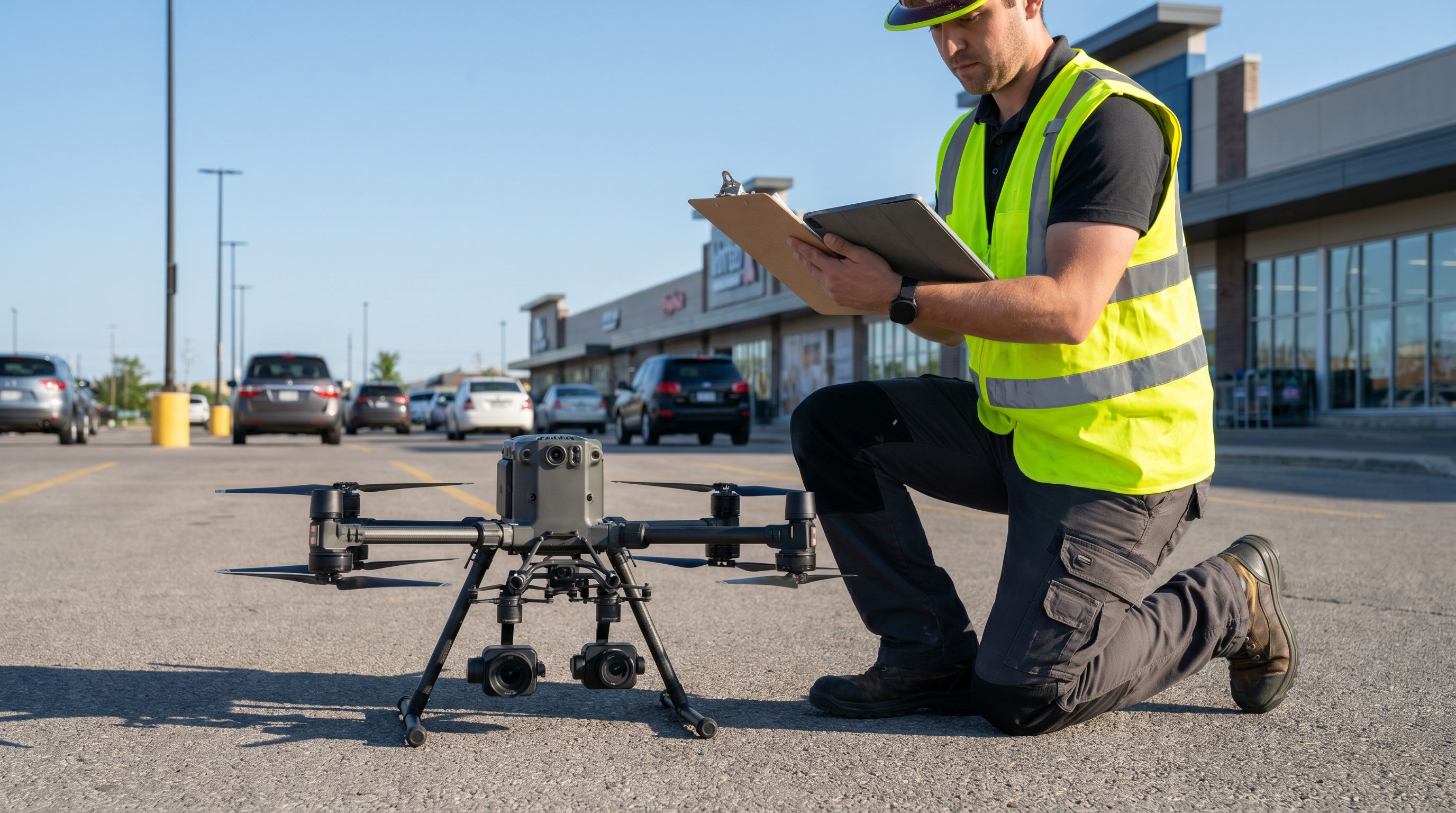
Equipment Inspection. All aerial systems, batteries, cameras, and sensors are inspected and tested before deployment. Battery state-of-health is verified — not just charge level — and redundant batteries are packed for each flight to ensure full site coverage without interruption. Drone FAA registration is confirmed current.
Flight Plan Review. The pilot reviews the specific documentation scope: which areas of the roof or site require coverage, what deliverable types are needed (orthomosaic, thermal, 3D, video), and what altitude and overlap patterns are required to achieve the resolution and geometry accuracy specified. For retail sites, the flight plan accounts for adjacent structures, signage, overhead utilities, and parking lot geometry.
On-Site Preparation for Retail and Occupied Commercial Properties
Retail and commercial properties present specific on-site preparation considerations that differ from vacant land or construction sites.
Site Survey. On arrival, the pilot conducts an on-foot survey of the property boundary, rooftop access points, and surrounding airspace before launching. Emergency landing zones are identified. Overhead utilities, antennas, trees, and adjacent structures are noted and incorporated into the adjusted flight plan.
Stakeholder Coordination. Property managers, store managers, or site contacts are notified that drone operations are commencing. For multi-tenant retail centers, this typically means coordinating with the property management office rather than individual tenants. The notification confirms that no building maintenance or rooftop work is scheduled during the flight window.
Bystander Safety. The pilot confirms that the immediate flight area is clear of non-essential personnel. FAA Part 107 prohibits flight over uninvolved individuals. For active retail parking lots, this means establishing a safe operational perimeter — using safety cones or barriers where needed — and monitoring for pedestrian movement throughout the flight. For complex multi-structure sites, a ground observer may be deployed at the pilot’s discretion to maintain continuous visual contact.
Flight Operations and FAA Part 107 Compliance
Visual Line of Sight (VLOS). All flights maintain visual line of sight with the aircraft throughout the operation, as required by FAA Part 107. The pilot or a designated visual observer maintains continuous sight of the drone to monitor airspace and detect any conflicts.
Altitude Compliance. Flights do not exceed 400 feet above ground level (AGL) unless operating within 400 feet of a structure, where altitude may match the structure’s height. For tall commercial buildings or multi-story retail centers, the 400-foot structure exception allows the documentation of rooftop equipment and facades at the appropriate elevation.
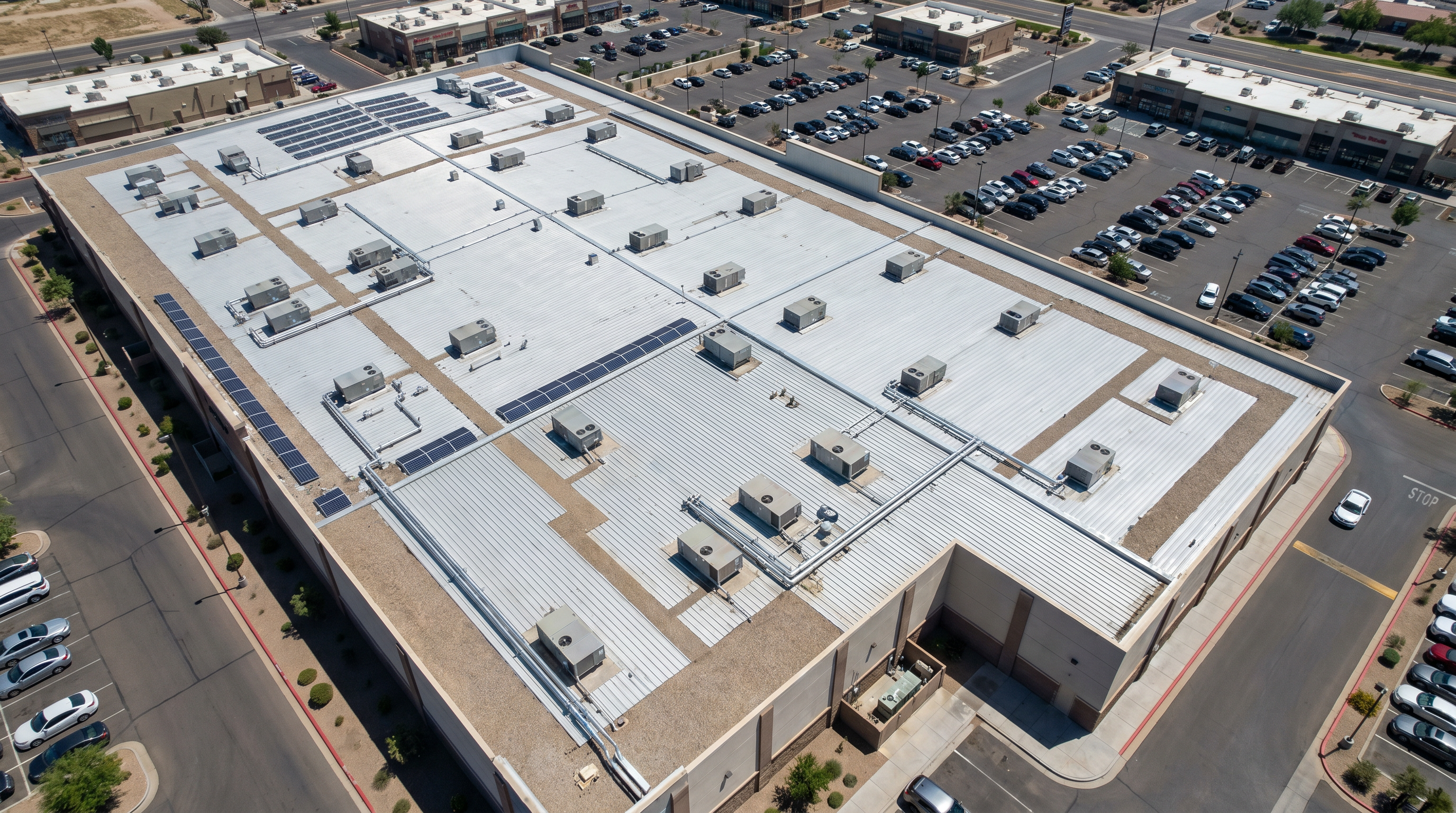
Structured Documentation Passes. Roof documentation begins with perimeter passes to establish spatial context, followed by systematic grid passes at the overlap percentage required for photogrammetric processing. Thermal imaging passes are flown at consistent speed and altitude to ensure uniform data collection across the entire roof surface. For orthomosaic production, flight altitude is calibrated to achieve the target ground sample distance — typically 1–3 cm per pixel for commercial site and roof documentation.
Battery Management. Battery levels are monitored continuously against the return-to-home threshold. All flights are planned with sufficient battery reserve for a safe return and landing. Where full roof coverage requires multiple battery cycles, flights are sequenced to maintain continuous coverage without compromising return margins.
Incident Response. If an airspace conflict, equipment anomaly, or site safety issue arises during flight, standard procedure is to land immediately at the nearest safe location and assess before resuming. Any incident reportable under FAA Part 107 is documented and filed appropriately.
What Professional FAA Part 107 Drone Documentation Delivers
The output of a professional commercial drone documentation flight is not just photographs — it is a structured set of deliverables calibrated to specific commercial real estate and facility management use cases.
| Deliverable | What It Provides | Common Use Cases |
|---|---|---|
| Orthomosaic Map | Georeferenced top-down aerial photograph at 1–3 cm/pixel resolution | Site planning, as-built documentation, area calculations, portfolio records |
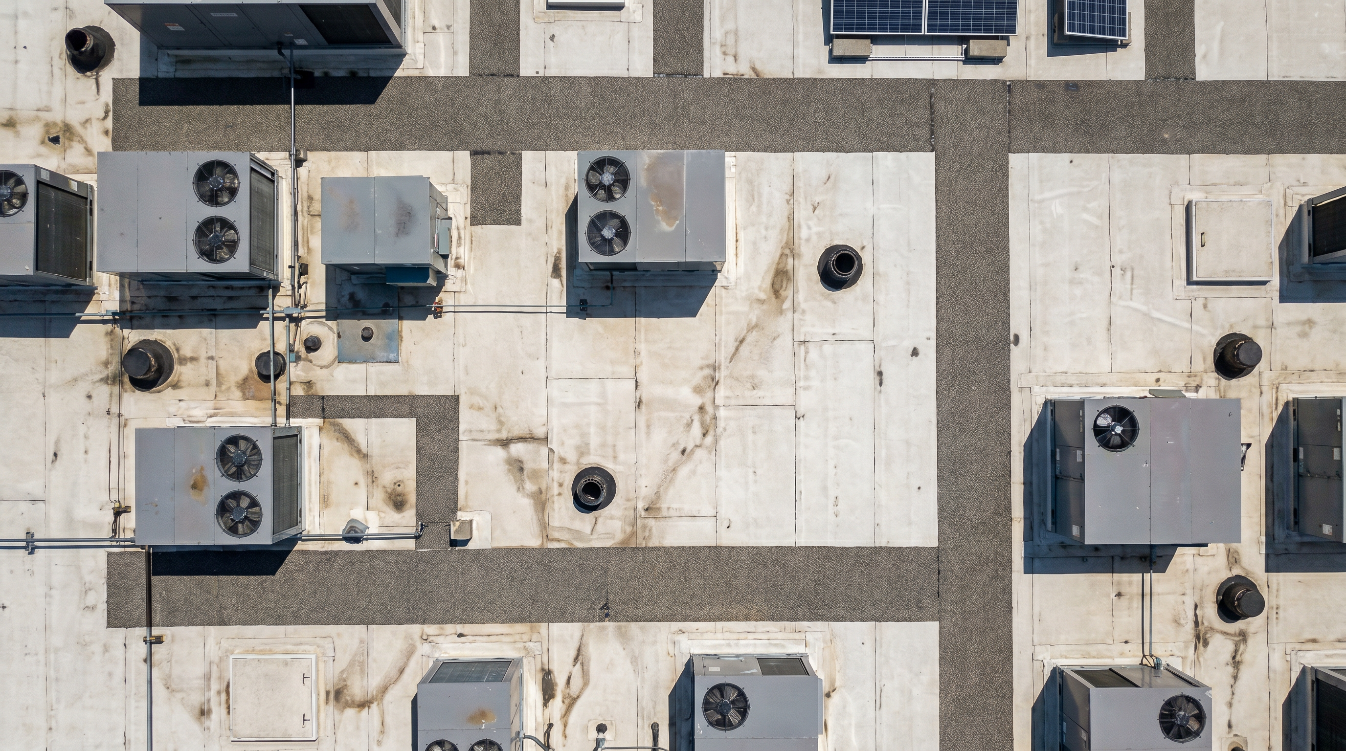
| Thermal Imagery | Infrared map identifying moisture intrusion, heat loss, HVAC anomalies | Roof inspection, energy audit, maintenance planning, insurance documentation |
| 3D Point Cloud | Dense 3D surface model of rooftops, facades, and site terrain | Roof measurement, facade documentation, BIM integration |
| 3D Mesh / VR Model | Photorealistic 3D model with accurate geometry and texture | Client presentations, adaptive reuse visualization, stakeholder reporting |
| Aerial Video & Photography | 4K aerial video and high-resolution stills from multiple angles | Marketing, leasing documentation, construction progress, executive reporting |
All standard deliverables are available within 3–5 hours of a site visit. For enterprise retail clients managing documentation across multiple locations, DroneDeploy integration enables automated flight planning, standardised processing, and centralised reporting across all sites. Full details on deliverable types, use cases, and the aerial documentation process are in the Aerial Drone Documentation Services overview, with interactive gallery examples at roboticimaging.com/aerial-drone.
The distinction between professional commercial drone documentation and consumer drone photography is significant for property owners and facility managers evaluating vendors. Professional FAA Part 107 operations bring airspace coordination, LAANC authorisation, structured flight planning, and processed deliverables — not raw footage. The difference shows up in the output: an orthomosaic map at 1–3 cm/pixel with georeferencing and area calculations is a different asset from aerial video taken by an unregistered operator. For retail site and roof documentation where the deliverable needs to stand up to insurance review, construction planning, or regulatory submission, the operational protocol behind the flight determines the usability of what comes out of it.
The distinction between professional commercial drone documentation and consumer drone photography matters for property owners and facility managers evaluating vendors. Professional FAA Part 107 operations deliver airspace coordination, LAANC authorisation, structured flight planning, and processed deliverables — not raw footage. An orthomosaic map at 1–3 cm/pixel with georeferencing and area calculations is a fundamentally different asset from aerial video taken by an unregistered operator. For retail site and roof documentation where deliverables need to support insurance claims, construction planning, or regulatory submissions, the operational protocol behind the flight determines the usability of what comes out of it.
Need a certified FAA Part 107 pilot for your site?
Robotic Imaging deploys FAA Part 107 certified UAS pilots for retail site and roof documentation in all US markets — with orthomosaic maps, thermal inspections, 3D models, and aerial photography ready within 3–5 hours of a site visit. Ground-based LiDAR documentation can be combined with aerial capture in a single field visit for complete interior and exterior documentation.
Request a quote →Frequently Asked Questions
What is FAA Part 107 and why does it matter for commercial drone documentation?
FAA Part 107 is the Federal Aviation Administration’s certification standard for commercial drone pilots in the United States. Any paid drone operation — including site documentation, roof inspection, and aerial photography for commercial real estate — requires a Part 107 certified Remote Pilot. Robotic Imaging’s aerial capture is performed exclusively by FAA Part 107 certified UAS pilots, ensuring every flight is legally compliant and operationally safe.
What is LAANC and when is it required for commercial site documentation?
LAANC (Low Altitude Authorization and Notification Capability) is the FAA’s automated system for obtaining airspace authorization in controlled airspace. Many commercial retail sites — particularly those near airports or in urban areas — fall within controlled airspace where LAANC approval is required before flight. Robotic Imaging’s pilots obtain all necessary authorizations as part of pre-flight planning, using FAA-approved applications including B4UFLY and Airmap.
Can drone documentation be combined with ground-based LiDAR scanning in a single site visit?
Yes. Robotic Imaging regularly combines aerial drone capture with ground-based LEICA RTC 360 LiDAR scanning in a single field deployment. The drone captures exterior conditions, rooftops, site geometry, and aerial context; the LiDAR scanner captures interior existing conditions for Scan-to-BIM or Scan-to-CAD deliverables. Together, they produce a complete digital documentation package for the property.
How long does a commercial roof and site drone documentation flight take?
Field time varies by site size, deliverable scope, and number of battery cycles required. Deliverables — orthomosaic map, thermal report, aerial photography — are processed and available within 3–5 hours of the site visit. For multi-site programs across 10–500+ locations, concurrent scheduling and DroneDeploy integration compress program timelines significantly.
All operational procedures, certifications, and service specifications reflect Robotic Imaging’s current standard practice as of June 2026. Robotic Imaging is ISO 27001 certified and SOC 2 Type II compliant. FAA Part 107 certified pilots. Available in all US markets.