Aerial Drone Documentation Services: Visual Capture for Commercial Real Estate
Robotic ImagingMay 22, 2026
Aerial Drone Documentation Services: Visual Capture for Commercial Real Estate
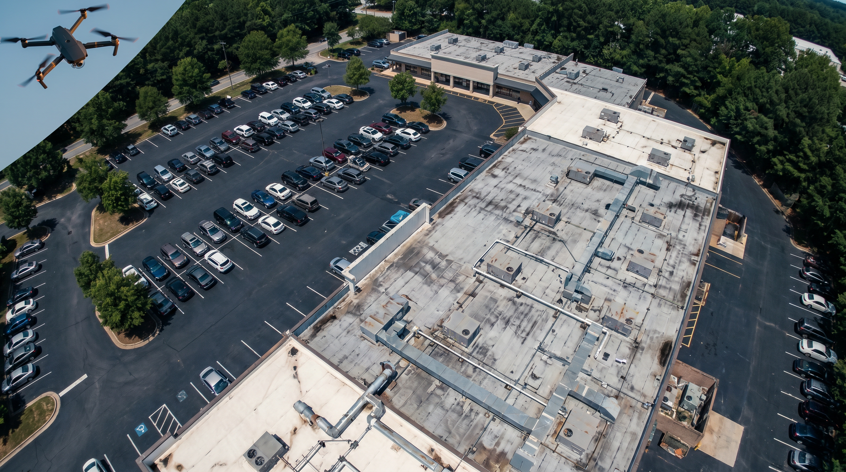
Aerial drone documentation gives project teams, facility managers, and property owners a complete picture of a site that ground-level survey and photography cannot provide. From orthomosaic maps and 3D surface models to thermal roof inspection and high-resolution photo galleries, Robotic Imaging’s FAA Part 107 certified drone pilots capture the full context of a building and its site — available in all markets, with deliverables ready within 3–5 hours of a site visit.
Request an Aerial Drone Quote →
Standard Drone Deliverables
We deploy a variety of drones on-site to standardise deliverables and save time on-site. The efficiency translates to cost savings and consistent deliverables across your projects. Our drone workflows enhance the safety of our crews while collecting tough existing conditions that are hard to understand from the ground. Our comprehensive aerial and ground-based capture is all done by experienced FAA Part 107 UAS Drone Pilots.
| Output Type | What It Captures | Format | Primary Use Cases |
|---|---|---|---|
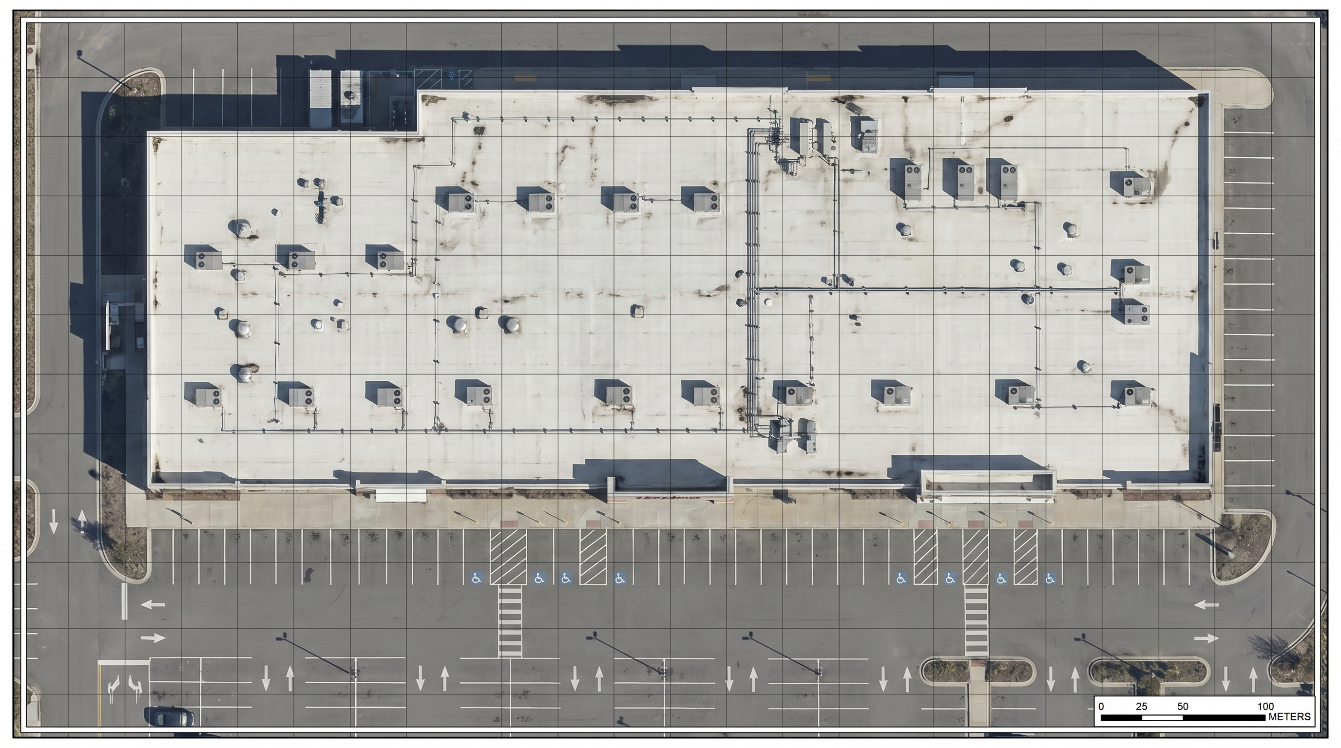
| Orthomosaic Map | Georeferenced top-down aerial photograph of the full site at centimeter-level resolution | .GeoTIFF, .JPEG, .PDF | Site planning, as-built documentation, area calculations, portfolio records |
| 3D Point Cloud | Dense 3D surface model of rooftops, facades, and site terrain from aerial photogrammetry | .LAS, .LAZ, .E57 | Roof documentation, facade measurement, terrain modeling, BIM integration |
| 3D Mesh / VR Model | Photorealistic 3D model of the building and site with accurate geometry and texture | .OBJ, .FBX, .GLB | Client presentations, visual documentation, adaptive reuse visualization |
| Thermal Imagery | Infrared heat map identifying moisture intrusion, heat loss, HVAC anomalies, and insulation failure | .JPEG, .TIFF, PDF report | Roof inspection, energy audit, maintenance planning, insurance documentation |
| Aerial Video & Photography | 4K aerial video footage and high-resolution stills from multiple angles and altitudes | .MP4, .JPEG, .RAW | Marketing, leasing documentation, construction progress, executive reporting |
| DroneDeploy Integration | Automated flight planning, data processing, and multi-site reporting via DroneDeploy platform | DroneDeploy dashboard, .PDF | Multi-site portfolio programs, automated progress reporting, enterprise rollouts |
Explore the Full Aerial Gallery
View Robotic Imaging’s aerial deliverable examples — Mapping, VR Mesh, and Photo Gallery — across commercial, retail, industrial, and adaptive reuse project types.
View Aerial Deliverable Gallery →What Drone Capture Provides That Ground Survey Cannot
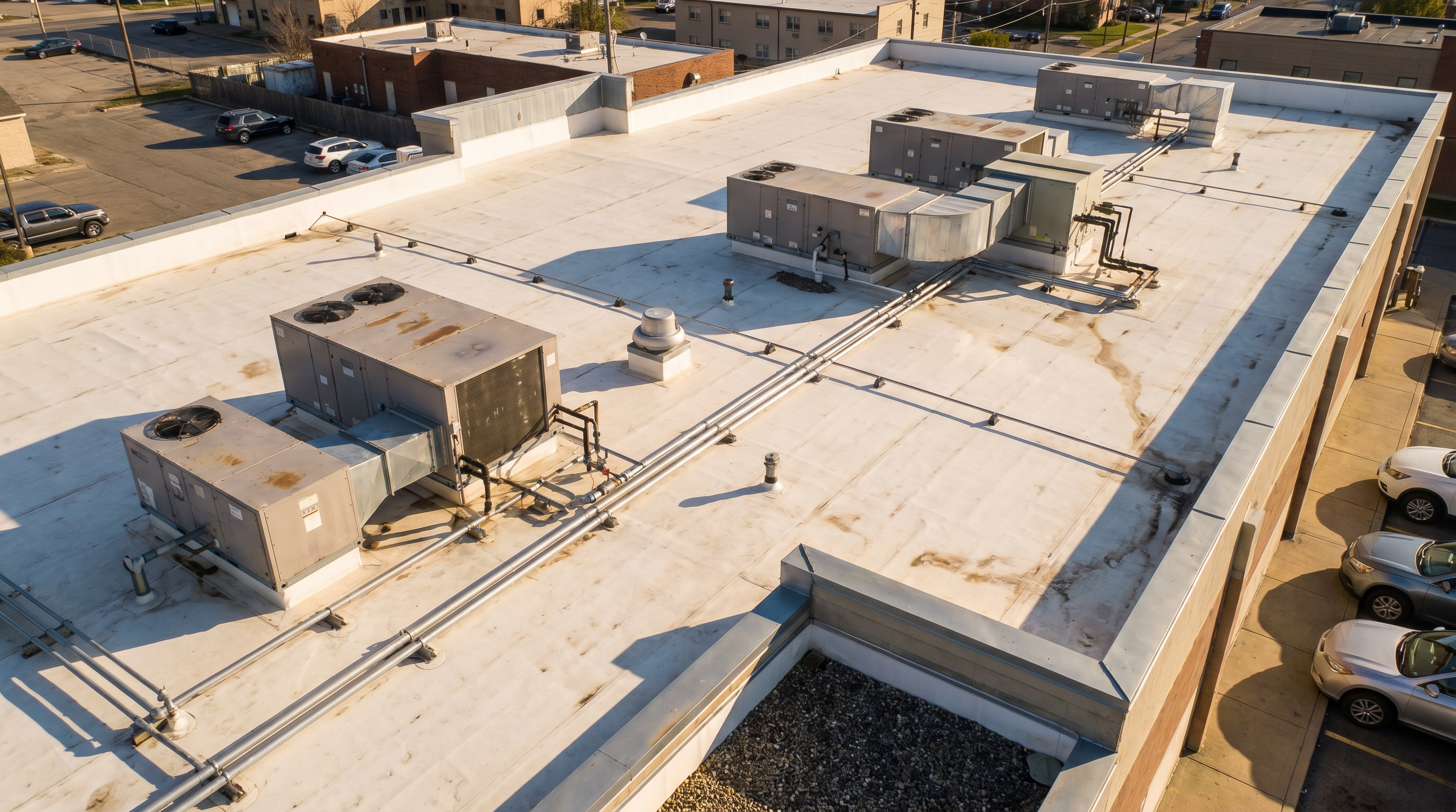
Our drones are equipped with high-resolution cameras and other sensors that provide detailed visual and thermal imagery. This enables comprehensive data collection and analysis, allowing for a more accurate assessment of a construction project’s progress or the condition of its roof.
A field technician at ground level can document walls, interiors, and accessible areas. A drone captures the full rooftop simultaneously — every HVAC unit, every drain, every penetration, every area of membrane discolouration — in a single flight, without lifts, scaffolding, or safety risk to crew. For retail roofs with steep pitches or tall structures, drone inspection is not just faster but often the only practical approach.
The same applies to site documentation. A commercial site with multiple structures, parking areas, utilities, and neighbouring buildings requires hours of ground-level survey to capture — and still produces an incomplete picture of how site elements relate to each other. A drone captures the complete site context in a single flight, producing a georeferenced orthomosaic that serves as the accurate base for design, renovation planning, and stakeholder presentations.
DroneDeploy Integrations can be made available for multi-site rollouts or 1-off adaptive reuse projects. For enterprise retail clients managing documentation across 50–500+ locations, DroneDeploy enables automated flight planning, standardised data processing, and centralised reporting across all sites in a single platform.
Drone Documentation Use Cases
| Use Case | What Drone Capture Provides | Advantage Over Traditional |
|---|---|---|
| Retail roof inspection | Thermal and visual documentation of rooftop conditions — HVAC units, drainage, penetrations, membrane condition | Access to steep pitches and tall structures without lifts, scaffolding, or safety risk |
| Construction progress monitoring | Dated aerial photographs and orthomosaics showing site progress at every phase | Single flight captures entire site in hours vs days of ground-level photography |
| Pre-renovation site documentation | Complete site context — building footprint, parking, utilities, neighbouring structures — before design begins | Captures site geometry and conditions manual survey misses or approximates |
| Adaptive reuse documentation | Existing conditions of complex multi-building sites for phased renovation planning | Captures relationships between structures and site elements at scale |
| Multi-site portfolio programs | Standardised aerial documentation across 10–500+ locations in a consistent format | DroneDeploy integration enables automated processing and uniform output across all sites |
| Insurance & compliance | Timestamped photographic and thermal record of building condition for insurance, warranty, and compliance | Provides defensible visual evidence of site condition at a specific date |
| Marketing & leasing | Cinematic aerial video and photography showing property context, access, and surroundings | Aerial perspective communicates site value and scale that ground photography cannot |
Understanding the Three Output Types: 3D, Orthomosaic, and Thermal
Robotic Imaging’s imaging can produce 3D, orthomosaic, and thermal outputs. Each of these aerial maps has distinct benefits — from pre-planning and monitoring progress to understanding a site’s layout — available 3–5 hours after a site visit. This level of data is precise compared to satellite imaging or plane imaging.
Orthomosaic maps are geometrically corrected, georeferenced top-down photographs stitched from dozens or hundreds of individual drone images into a single accurate map. Unlike satellite imagery — captured from altitude with inherent distortion and resolution limits — a drone orthomosaic is captured at low altitude (typically 100–400 feet) with a ground sample distance of 1–3 cm per pixel. That resolution shows individual roof membrane seams, drain locations, equipment labels, and pavement conditions. Satellite imagery shows the same rooftop as a grey rectangle.
3D surface models and VR meshes derived from drone photogrammetry provide accurate geometry of rooftops, facades, and site terrain. These models integrate with Scan-to-BIM workflows for complete building documentation — the drone captures exterior and site context while ground-based LiDAR scanning captures interior existing conditions. Combined, they produce a complete digital twin of the property.
Thermal imaging uses infrared sensors to capture heat signatures across rooftop surfaces. For facility managers and building owners, thermal drone inspection identifies moisture intrusion (wet insulation retains heat and shows as warm anomalies), heat loss through failing membrane or insulation, HVAC performance issues, and electrical equipment running hot. A single thermal flight over a commercial roof produces a defensible, timestamped record of condition that is directly actionable for maintenance planning, insurance claims, and warranty documentation.
Safety, Accessibility, and Scalability
Our drone workflows enhance the safety of our crews while collecting tough existing conditions that are hard to understand from the ground. The accessibility and versatility of our aerial systems capture hard-to-reach areas that might be challenging for humans — roofs with steep pitches, tall structures, confined access sites — with their versatility allowing them to adapt to various retail, construction, and inspection needs.
Drone documentation also has a smaller carbon footprint compared to traditional inspection methods such as using heavy machinery or manned aircraft, contributing to more environmentally responsible operations. The data collected can be processed through software and analysed to generate reports and insights quickly — this data-driven approach improves decision-making and problem-solving across construction and inspection programs.
Scalability is a defining characteristic. Whether it’s a single retail store or a multi-site retail development, drones adapt to the requirements. Incorporating drone documentation offers a 3D technological edge that enhances safety, efficiency, and precision across the adaptive reuse industry. By harnessing the power of aerial technology, businesses can streamline their operations, reduce costs, and ensure the quality and longevity of their structures. We make construction documentation drones available in all markets.
Frequently Asked Questions
Are Robotic Imaging drone pilots FAA certified?
Yes. All aerial capture is performed by experienced FAA Part 107 UAS Drone Pilots — the commercial certification required for any paid drone operations in the United States. Every flight includes airspace authorisation, site safety assessment, and full operational documentation.
What drone deliverables does Robotic Imaging produce?
Robotic Imaging produces orthomosaic maps, 3D point clouds, 3D mesh and VR models, thermal imagery, aerial video, and high-resolution photography. DroneDeploy integration is available for multi-site programs. Deliverables are ready within 3–5 hours of a site visit for standard outputs.
What is a drone orthomosaic map and how is it different from satellite imagery?
A drone orthomosaic is a georeferenced, geometrically corrected aerial photograph stitched from dozens of low-altitude drone images at 1–3 cm per pixel resolution. Satellite imagery is captured from orbit with inherent resolution limits — typically 30–50 cm per pixel at best for commercial providers. For commercial property documentation, drone orthomosaics show individual roof details, drainage, and equipment that satellite imagery cannot resolve.
Can drone documentation integrate with Scan-to-BIM or Scan-to-CAD workflows?
Yes. Drone-derived 3D point clouds and surface models integrate with Scan-to-BIM and Scan-to-CAD workflows. The drone captures exterior and site context while ground-based LEICA LiDAR scanning captures interior existing conditions — producing a complete digital twin of the property.
What is DroneDeploy integration and when is it useful?
DroneDeploy is a drone operations platform that enables automated flight planning, standardised data processing, and centralised reporting. Robotic Imaging’s DroneDeploy integration is available for multi-site rollouts and adaptive reuse projects — particularly useful for enterprise retail clients managing aerial documentation across 50+ locations who need consistent output formats and centralised reporting.
Does Robotic Imaging offer thermal drone inspection for roofs?
Yes. Thermal imaging identifies moisture intrusion, heat loss through failing membrane or insulation, HVAC performance anomalies, and overheating electrical equipment. Thermal drone inspection is particularly valuable for retail facilities managers and building owners planning maintenance, submitting insurance claims, or documenting building condition for warranty purposes.
Is drone documentation available nationwide?
Yes. Robotic Imaging makes construction and commercial documentation drones available in all markets. Field technician dispatch within 2–3 days of scheduling. Contact the team with your location and project scope for scheduling.
How does aerial drone documentation complement ground-based LiDAR scanning?
Ground-based LiDAR scanning (LEICA RTC 360, LEICA BLK 360 G2) captures interior existing conditions at ±2–4mm accuracy. Aerial drone capture covers the building exterior, rooftop, and site context that ground-based scanning cannot reach. Combined, the two capture methods produce a complete record of the property — inside and out — that feeds into Scan-to-BIM, Scan-to-CAD, and digital twin deliverables.
Get Started with Aerial Drone Documentation
Robotic Imaging’s FAA Part 107 certified drone pilots are available nationwide for single-site inspections, multi-location portfolio programs, construction progress monitoring, roof inspections, and adaptive reuse documentation. Deliverables within 3–5 hours of site visit for standard outputs.
Request an aerial drone quote — provide your location, site type, and required deliverables for a project-specific proposal.
View the full aerial deliverable gallery — Mapping, VR Mesh, and Photo Gallery examples from real Robotic Imaging projects before scoping your engagement.
Combine with Scan-to-BIM — add interior LiDAR scanning to complete the full building documentation picture.
Explore the platform sandbox — see how Robotic Imaging organises and delivers project documentation across a portfolio.
All specifications, delivery timelines, certifications, and client references reflect verified data from roboticimaging.com as of May 2026. FAA Part 107 certified. Drone documentation available in all US markets. DroneDeploy integration available for multi-site programs.