Scan-to-BIM vs Traditional Surveying: Cost, Speed, and Accuracy Compared
Robotic ImagingMay 20, 2026
Scan-to-BIM vs Traditional Surveying: Cost, Speed, and Accuracy Compared
Choosing between Scan-to-BIM laser scanning and traditional surveying is a cost-timeline-accuracy tradeoff, not a preference for new technology over established methods. For most commercial projects under 5,000 square feet with simple geometry and no BIM requirement downstream, traditional surveying is perfectly serviceable. For anything larger, more complex, or where a Revit model is part of the deliverable, the calculation shifts quickly — and not just on cost.
This comparison breaks down both methodologies across the factors that actually drive the decision: per-square-foot cost, field capture and total delivery timelines, measurement accuracy, and deliverable formats. A decision framework at the end of this article maps project characteristics to the right methodology.
Request a Scan-to-BIM Quote from Robotic Imaging →
What Each Method Actually Does
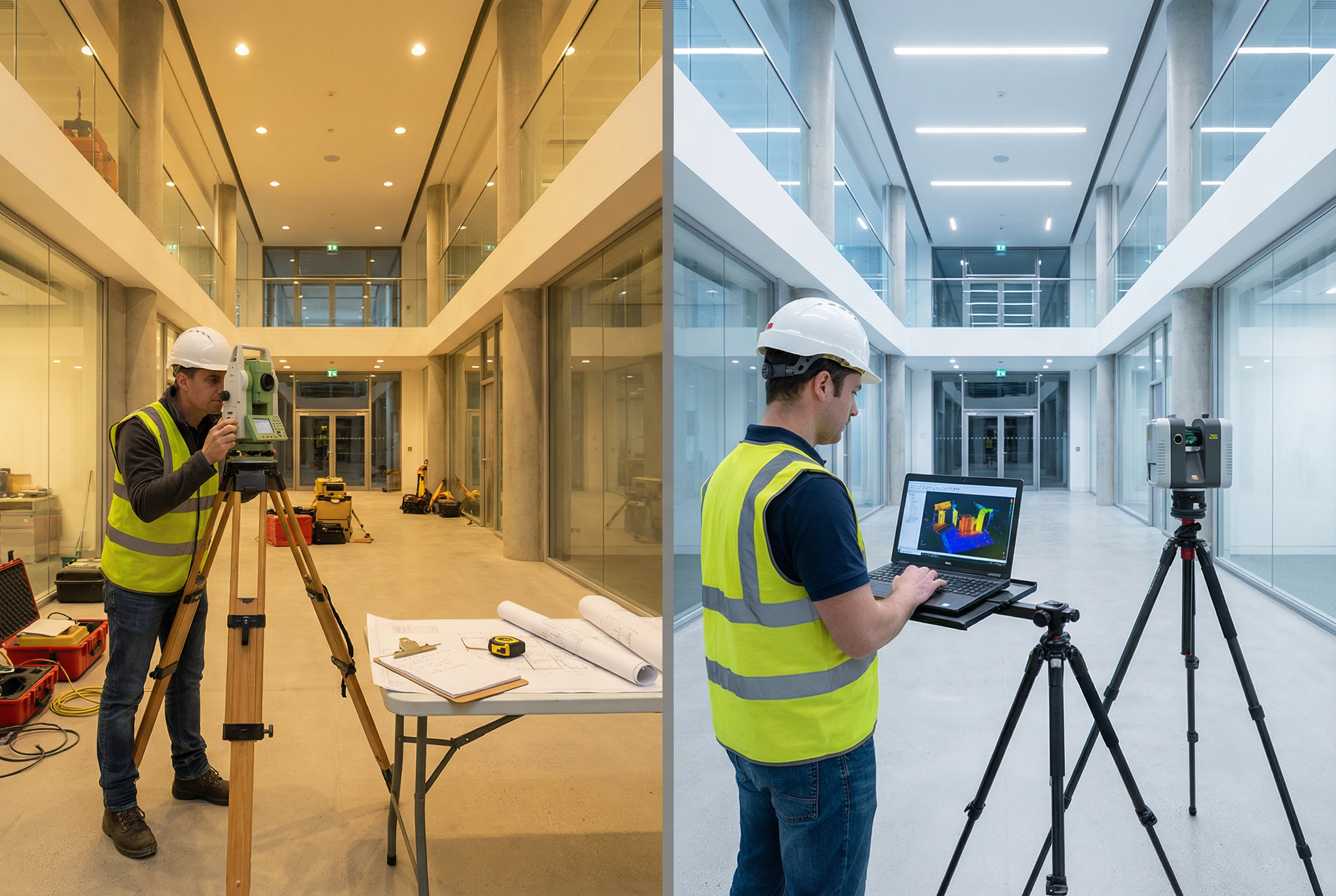
Traditional surveying for building documentation involves a field team using total stations, measuring tapes, and manual sketches to capture dimensions, elevations, and spatial relationships. That data is transcribed into 2D CAD drawings — typically AutoCAD .DWG files — and delivered several weeks after fieldwork begins. The methodology is proven and appropriate for straightforward scopes where dimensional precision requirements are modest and a 2D CAD output is sufficient.
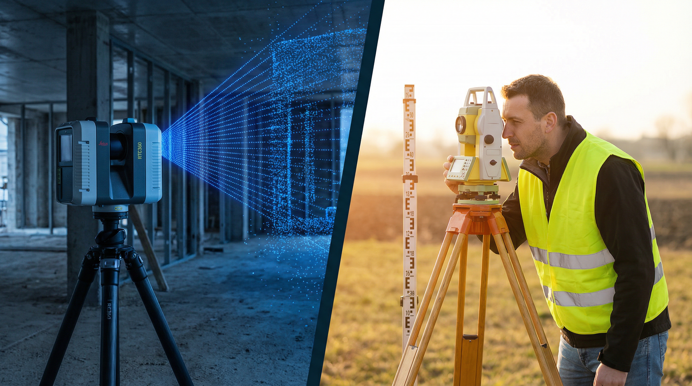
Scan-to-BIM laser scanning uses terrestrial LiDAR scanners to capture millions of precise spatial measurements per second from multiple positions throughout a building. Each scan position generates a dense point cloud — a three-dimensional dataset of every visible surface within the scanner’s range. After field capture, point cloud registration combines individual positions into a unified, spatially accurate model of the entire building. That registered point cloud then serves as the source geometry for BIM model production in Revit, 2D CAD drafting, and all derivative formats — all from a single field capture event.
Robotic Imaging uses the LEICA RTC 360 as its primary scanner: 2,000,000 points per second, ±2mm accuracy at up to 130m range. The LEICA BLK 360 handles tighter interior spaces at 680,000 points per second and ±4mm accuracy.
Cost Comparison: Per-Square-Foot Pricing
The most common question when evaluating Scan-to-BIM services vs traditional surveying is cost per square foot. The headline comparison favours laser scanning at scale, but the full picture requires including hidden costs that rarely appear in a surveyor’s initial quote.
Robotic Imaging’s Scan-to-CAD service starts at $0.19 per square foot — confirmed on the live services page. Scan-to-BIM pricing scales with the Level of Development required and project complexity. Traditional surveying for equivalent commercial documentation typically runs $0.50–$2.00 per square foot depending on scope, geometry, and market, though these rates vary significantly by region and firm.
| Factor | Traditional Surveying | Scan-to-BIM Laser Scanning |
|---|---|---|
| Scan-to-CAD pricing | $0.50–$2.00/sqft (est.) | From $0.19/sqft |
| Break-even threshold | Competitive under 5,000 SF | Cost-competitive at 5,000–10,000 SF+ |
| Rework risk | High — manual transcription errors | Low — point cloud is source of truth |
| Hidden cost exposure | Change orders, repeat site visits | Minimal — single capture event |
| Deliverable value | 2D CAD only (.DWG) | BIM + Point Cloud + CAD + VR Tours |
The per-square-foot gap narrows when hidden costs are factored into the traditional surveying total. A single change order on a commercial renovation project traced to inaccurate as-built documentation routinely costs $5,000–$50,000 depending on scope. That exposure rarely appears in methodology cost comparisons, but it’s the most significant financial differentiator at scale.
Timeline Comparison: Field Capture to Final Deliverable
The timeline gap between laser scanning and manual surveying is most visible during field capture, but it compounds through the entire delivery cycle.
Robotic Imaging’s end-to-end delivery runs 10–14 business days from scheduling to final deliverable: 2–3 days for field capture, 3–5 days for point cloud processing, and 7–10 days for BIM or CAD modeling. Field technicians can be dispatched within 2–3 days of scheduling, with full timeline breakdown available here.
| Phase | Traditional Surveying | Scan-to-BIM Laser Scanning |
|---|---|---|
| Field capture | 1–2 weeks | 2–3 days |
| Processing & drafting | 2–3 weeks | 7–10 days |
| Total delivery | 3–5 weeks | 10–14 business days |
| Revision cycles | Common — field gaps discovered in design | Rare — complete point cloud eliminates gaps |
| Occupied building disruption | Extended — 1–2 weeks floor access | Minimal — 2–3 days on-site |
The revision cycle difference is practically significant. Traditional surveys frequently require return field visits when designers discover unmeasured conditions during design development. A complete point cloud eliminates that gap — every surface captured in the original scan remains queryable without returning to the building. For occupied commercial buildings where floor access must be scheduled around business operations, compressing site time from 1–2 weeks to 2–3 days meaningfully reduces tenant disruption costs and keeps project schedules intact.
Accuracy Comparison: Measurement Tolerances That Matter
Manual field measurement carries an accuracy tolerance of ±1–3 inches depending on methodology and space complexity. In straight-corridor office layouts with simple rectangular geometry, that tolerance is workable. In spaces with curved walls, mechanical rooms, dense MEP systems, or tight coordination between structural and systems, a 2-inch error in as-built documentation can generate change orders that dwarf the original survey cost.
Laser scanning achieves ±2–4mm accuracy depending on equipment — approximately 10x tighter than manual methods. For projects with MEP coordination requirements, curtain wall systems, or dimensional tolerances critical to construction coordination, the accuracy gap is not theoretical. It directly determines whether the design model coordinates cleanly with actual field conditions when construction begins.
The deliverable format gap is where the methodology difference is most pronounced for downstream project teams:
| Factor | Traditional Surveying | Scan-to-BIM (Robotic Imaging) |
|---|---|---|
| Measurement accuracy | ±1–3 inches (manual) | ±2–4mm (±1/16–1/4 inch) |
| 2D CAD (.DWG) | ✓ | ✓ |
| Revit BIM (LOD 200–LOD 400) | ✗ | ✓ |
| Point Cloud (RCS, RCP, E57, LAS) | ✗ | ✓ |
| 360° Virtual Tour | ✗ | ✓ |
| Permanent spatial archive | ✗ | ✓ |
| Multi-format from one site visit | ✗ | ✓ |
Traditional surveying produces one deliverable: 2D CAD. Scan-to-BIM produces all formats from a single field capture — and the point cloud archive remains available indefinitely for future project phases, facility management, capital planning, or downstream renovation work.
When Traditional Surveying Still Makes Sense
It would be dishonest to recommend laser scanning for every project. Traditional surveying remains the right choice in specific circumstances.
The methodology is appropriate when a project scope is under 3,000–5,000 SF with simple rectangular geometry, the deliverable requirement is 2D CAD only with no BIM model needed downstream, budget is highly constrained and rework risk is genuinely low, and single-visit access is reliable in an unoccupied space. For a straightforward single-room punch list or a small tenant improvement where the design team only needs a dimensioned floor plan, a skilled drafter with a laser measure is a perfectly reasonable solution.
Where traditional surveying consistently underperforms is on projects where any of these conditions aren’t met: the space is complex, the scope exceeds 5,000 SF, the downstream deliverable includes a BIM model, or the building is occupied and access is constrained. In those scenarios, the hidden costs of the manual approach reliably exceed its apparent price advantage.
Decision Framework: Matching Method to Project
| Project Characteristic | Traditional Surveying | Scan-to-BIM |
|---|---|---|
| Under 5,000 SF, simple geometry | ✓ Appropriate | ✗ Overkill |
| 5,000–10,000 SF | ⚠ Borderline | ✓ Cost-competitive |
| Over 10,000 SF | ✗ Not competitive | ✓ Clear choice |
| Complex MEP or multi-floor | ✗ High rework risk | ✓ Required |
| BIM model needed downstream | ✗ Cannot produce | ✓ Included |
| Multi-location program | ✗ No consistency | ✓ Standardised |
| Occupied building, tight access | ✗ Extended disruption | ✓ 2–3 day capture |
| Point cloud archive has future value | ✗ No archive | ✓ Permanent record |
A hybrid approach works in a specific situation: a project combining a straightforward primary scope (where traditional surveying is sufficient) with isolated high-complexity zones — mechanical penthouses, ornate lobby features, or tight MEP coordination areas — where laser scanning accuracy is warranted only in targeted areas. This is less common but can make sense on projects where budget constraints are real and only a portion of the scope demands point cloud precision.
For multi-location programs — retail renovation rollouts, corporate real estate portfolios, tenant improvement programs across dozens of properties — the decision is less complicated. Manual surveying cannot deliver consistent documentation standards across hundreds of locations at scale. Robotic Imaging has documented over 100 million square feet across Fortune 500 multi-site programs including Walmart, 7-Eleven, Kroger, CVS, Nordstrom, and JLL — programs where documentation consistency and speed across locations makes the methodology choice straightforward.
Frequently Asked Questions
How much does Scan-to-BIM cost compared to traditional surveying?
Robotic Imaging’s Scan-to-CAD service starts at $0.19 per square foot. Scan-to-BIM pricing scales with the Level of Development required. Traditional surveying for commercial documentation typically runs $0.50–$2.00 per square foot, though this varies significantly by region, firm, and project complexity. Scan-to-BIM becomes cost-competitive at 5,000–10,000 SF when hidden costs — change orders, repeat site visits, transcription errors — are included in the traditional surveying total.
How accurate is laser scanning compared to traditional surveying?
Robotic Imaging’s LEICA RTC 360 achieves ±2mm accuracy. The LEICA BLK 360 achieves ±4mm. Both are approximately 10x tighter than the ±1–3 inch tolerance typical of manual measurement methods. For projects with MEP coordination, curtain wall systems, or tight dimensional tolerances, the accuracy difference directly affects whether the design model coordinates with field conditions when construction starts.
How long does Scan-to-BIM take compared to traditional surveying?
Robotic Imaging delivers complete Scan-to-BIM documentation in 10–14 business days from scheduling — 2–3 days field capture, 3–5 days point cloud processing, 7–10 days BIM or CAD modeling. Traditional surveying for equivalent commercial scope typically takes 3–5 weeks from field capture to final deliverable. See the full LOD level guide for deliverable detail by level.
What deliverables does Scan-to-BIM produce that traditional surveying cannot?
From a single field capture, Scan-to-BIM produces: Revit BIM models at LOD 200 through LOD 400, point cloud files (RCS, RCP, E57, LAS), 2D CAD drawings (.DWG, .DXF, .PDF), and 360° virtual walkthroughs. Traditional surveying produces 2D CAD only. The point cloud archive also remains queryable for future project phases without returning to the building.
When does traditional surveying make more sense than Scan-to-BIM?
Traditional surveying is appropriate for scopes under 3,000–5,000 SF with simple geometry, where the only deliverable required is a 2D CAD floor plan, rework risk is genuinely low, and the space is unoccupied with reliable single-visit access. For anything larger, more complex, occupied, or requiring a BIM model downstream, Scan-to-BIM is the stronger choice on both cost and quality when hidden costs are included.
Can I get a Scan-to-BIM quote for my project?
Yes. Robotic Imaging provides quotes based on square footage, Level of Development required, project timeline, and number of locations. Contact the team here or explore the live sandbox to see deliverable samples before requesting a quote.
Getting Started with Scan-to-BIM
The methodology decision for most commercial projects above 5,000 SF isn’t close. The per-square-foot cost advantage of Scan-to-BIM versus traditional surveying — before accounting for change order risk reduction, faster delivery, and multi-format deliverable value — makes the case on its own. Add the accuracy gap and the point cloud archive value, and the comparison favours laser scanning on every dimension that matters for complex commercial work.
For projects where you’re genuinely uncertain, the break-even threshold is the deciding variable. At 5,000–10,000 SF, run the numbers including one realistic change order scenario. In most cases, the math resolves the question.
Request a quote from Robotic Imaging — provide square footage, LOD requirements, and timeline for a project-specific proposal.
View Scan-to-BIM and Scan-to-CAD service samples — see LOD 300 and LOD 350 deliverable examples before committing to a scope.
Explore the live sandbox — see how Robotic Imaging’s platform organises and delivers documentation across a portfolio.
All pricing, delivery timelines, accuracy specifications, and client references reflect verified data from roboticimaging.com as of May 2026. Robotic Imaging is ISO 27001 certified and SOC 2 Type II compliant.