LiDAR’s Transformative Impact on the AEC Industry: Architecture, Engineering, and Construction
Robotic ImagingJune 2, 2026
LiDAR’s Transformative Impact on the AEC Industry: Architecture, Engineering, and Construction
LiDAR (Light Detection and Ranging) is the foundational technology behind the AEC industry’s most significant documentation shift in decades. By emitting laser pulses and measuring their return time, LiDAR scanners build dense, survey-grade 3D point clouds of any built environment at ±2mm accuracy — data that becomes the source geometry for Scan-to-BIM models, Scan-to-CAD drawings, and as-built documentation across commercial, industrial, and institutional projects. For architects, engineers, and construction teams, LiDAR has replaced weeks of manual site measurement with 2–3 day field captures and 10–14 business day deliverable turnaround, at 50–80% faster speed than traditional surveying for equivalent commercial scopes.
Get a LiDAR documentation quote →
What Is LiDAR and How Does It Work in AEC?
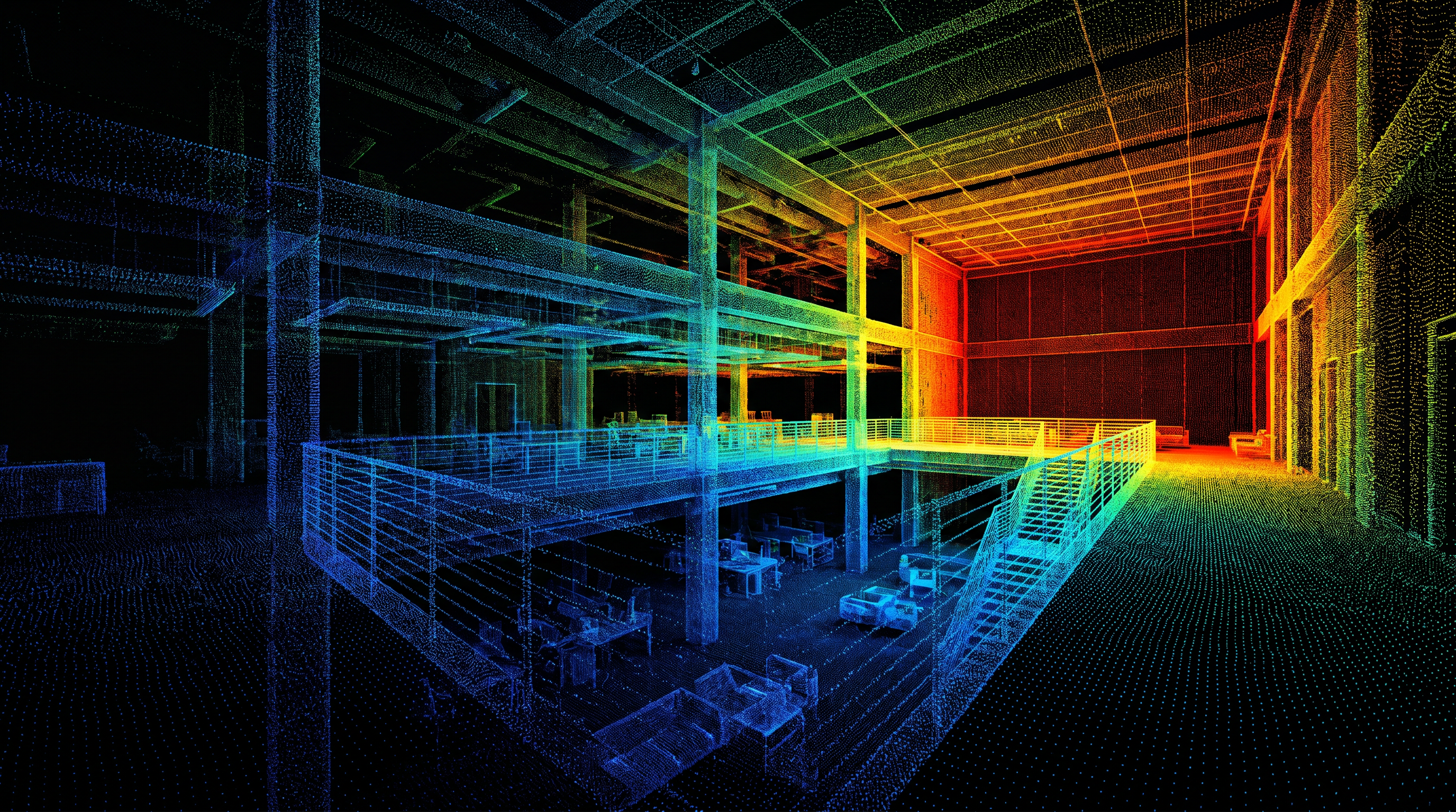
LiDAR works by emitting millions of laser pulses per second and measuring the precise time each pulse takes to return after bouncing off a surface. The result is a point cloud — a dense 3D data set where each point represents a real, measured position in space. In AEC applications, that point cloud becomes the authoritative record of a building’s existing conditions: every wall, column, ceiling, floor, opening, and MEP system captured simultaneously at survey-grade precision.
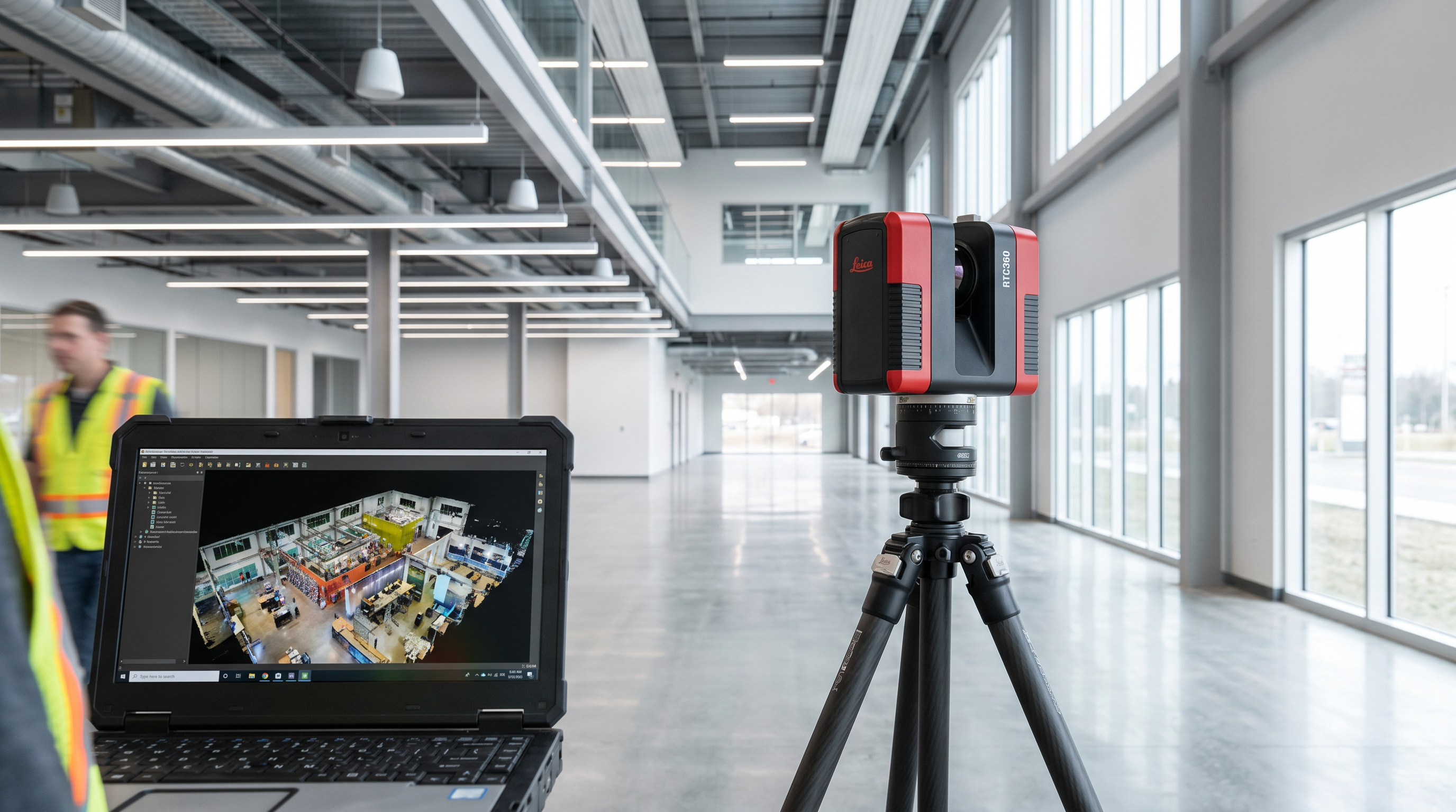
Robotic Imaging deploys the LEICA RTC 360 as its primary field scanner — capturing 2,000,000 points per second at ±2mm accuracy, with a 130m range that covers large commercial floor plates in a single scan position sequence. Scanner positions are selected to achieve complete coverage with overlapping zones that eliminate shadow areas and blind spots. A typical retail floor or office plate is fully captured in a single field day; multi-floor facilities take 2–3 days. For the complete overview of how this translates into delivered documentation, see the Complete Guide to Scan-to-BIM Services.
How Has LiDAR Changed AEC Documentation?
Before LiDAR, existing conditions documentation relied on manual measurement — tape measures, laser distance meters, and field sketches that captured only what a person physically reached, at ±¼–½ inch accuracy under ideal conditions. Complex ceiling conditions, above-grid MEP routing, and irregular column layouts either required assumptions or additional return visits to resolve.
LiDAR removes both problems. The LEICA RTC 360 at ±2mm is 3–6x more precise than manual methods and captures every visible surface — including ceiling conditions and above-grid MEP routing — without requiring individual access to each element. The result is a complete, accurate existing conditions record delivered without the repeat site visits that manual surveys routinely generate. For a detailed cost and speed breakdown, see Scan-to-BIM vs Traditional Surveying: Cost, Speed, and Accuracy Compared.
LiDAR Applications Across the AEC Industry
| Application | What LiDAR Delivers | Who Uses It |
|---|---|---|
| Scan-to-BIM | Intelligent 3D Revit model at LOD 200–400 for design, MEP coordination, and clash detection | Architects, MEP engineers, BIM managers, construction PMs |
| Scan-to-CAD | 2D as-built drawings — floor plans, RCPs, elevations, sections — in DWG, DXF, and PDF | Architects, GCs, facility managers, space planners |
| Renovation documentation | Verified existing conditions before design begins, eliminating field verification trips during design development | Design-build firms, TI teams, developers |
| Historic preservation | LOD 350–400 elevations, sections, and facade drawings from structures without original drawings | Preservation architects, structural engineers |
| Multi-location retail programs | Concurrent documentation across 50+ locations with standardised LOD 300 output and consistent accuracy | Retail facilities teams, corporate real estate |
For architects integrating LiDAR into renovation and CD workflows, see The Architect’s Platform for As-Built Documentation. For a plain-language introduction to the scanning process itself, see What Is Laser Scanning for Buildings?
What LiDAR Delivers: Scan-to-BIM, Scan-to-CAD, and Point Cloud
A LiDAR point cloud is the raw material. The deliverable depends on the project’s downstream workflow:
Scan-to-BIM converts the point cloud into an intelligent 3D Revit model at LOD 200–400 — for projects requiring MEP coordination, clash detection, or BIM-based facility management after construction.
Scan-to-CAD converts the same point cloud into 2D as-built drawings — floor plans, RCPs, elevations, sections, MEP documentation — starting at $0.19 per square foot. For teams working in AutoCAD rather than Revit, Scan-to-CAD delivers verified existing conditions without the cost of full BIM modeling.
Point cloud delivery provides the registered 3D data set in RCS, E57, and LAS formats for teams needing raw scan data for custom modeling or software integration. Choosing the right deliverable — and the right LOD — is covered in the LOD 300 vs LOD 350 vs LOD 400 guide.
LiDAR at scale: Robotic Imaging’s track record
100+ million square feet documented since 2017 for Walmart, 7-Eleven (1,000+ sites), Kroger, CVS, T-Mobile, and Lululemon. EKahn Development used a single LiDAR engagement to convert a 130,000 sq ft industrial property into 2D line drawings and a Revit model. Puratos Inc. received accurate 2D AutoCAD drawings for a manufacturing plant with no existing digital documentation, enabling a full production floor upgrade. Read client testimonials →
Frequently Asked Questions
What is LiDAR used for in the AEC industry?
LiDAR is used in AEC for existing conditions documentation, Scan-to-BIM modeling, Scan-to-CAD 2D drawing production, renovation as-built surveys, historic preservation, and multi-location retail documentation. It replaces manual measurement with ±2mm accurate point cloud data captured in 2–3 field days — 50–80% faster than traditional surveying for equivalent commercial scopes.
How accurate is LiDAR scanning for commercial buildings?
The LEICA RTC 360 captures at ±2mm accuracy (±1/16 inch) — 3–6x tighter than manual measurement. This accuracy is maintained across ceiling surfaces, above-grid MEP routing, and complex geometry that manual surveys routinely approximate, making it the standard for renovation documentation and permit-ready as-built drawings.
What is the difference between LiDAR and traditional surveying in AEC?
Traditional surveying achieves ±¼–½ inch accuracy under ideal conditions, captures only what a person physically reaches, and requires return visits for above-ceiling conditions. LiDAR captures every visible surface at ±2mm simultaneously and is 50–80% faster for equivalent commercial scopes.
How much does LiDAR scanning cost for a commercial building?
Robotic Imaging’s Scan-to-CAD documentation starts at $0.19 per square foot, covering field scanning, point cloud processing, and 2D drawing production. Scan-to-BIM pricing scales with LOD requirements and floor count. Contact Robotic Imaging with project square footage and deliverable type for a project-specific quote within two business days.
All pricing, delivery timelines, accuracy specifications, and client references reflect verified data from roboticimaging.com as of June 2026. LiDAR documentation from $0.19 per square foot. Robotic Imaging is ISO 27001 certified and SOC 2 Type II compliant.